
The Tamaki Regeneration Company is building thousands of homes on land an Auckland Council report has highlighted as being at high risk from the effects of climate change.
But what does it mean for the company responsible for the development, or the local authority that signed off the consents?
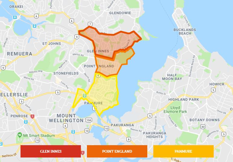
The properties are being built by the Tamaki Regeneration Company in partnership with HLC a subsidiary of Housing New Zealand and will see at least 7,500 state, affordable, KiwiBuild and private houses built over the next 20 years. The development is taking place on land in Point England, Glen Innes and Panmure which was previously home to 2,500 state houses. The Tamaki Regeneration Company was established in 2016 and is jointly owned by the government and the Auckland Council.
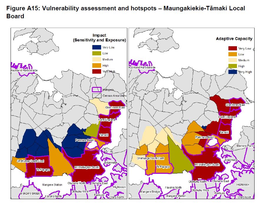
But a recently released report for the Auckland Council’s Research and Evaluation Unit (RIMU) titled: An assessment of vulnerability to climate change in Auckland, shows most of the area has been highlighted as being prone to the future effects of climate change.
The paper spells out how different areas in the Auckland region will be affected by climate change and how likely they will be to adapt to the changes. The ability for an area to adapt takes into account a number of elements, including socio-economic, demographic and climatic factors.
Glen Innes, Point England and Tamaki are all identified as vulnerability hotspots. Defined as areas likely to suffer from high levels of climate change impact with a low level of capacity to adapt.
Auckland Council chief sustainability officer John Mauro is more than aware of the growing concerns around climate change in the region. From flooding and extreme weather events to rising sea levels and increased temperatures, they are all issues the council is looking at in a series of research papers on climate change, which includes the latest RIMU report.
“Without seeing the actual the sea level rise and flooding maps for Tamaki I can’t articulate specifically what the risks are there,” Mauro says. “But I can acknowledge that they do exist in some locations and what we’re trying to do now is make sure that we now incorporate anticipated sea level rises into the maps we use for land use planning. We’re trying to include this information into the tools that we all use to make decisions around things like planning.”
Mauro says it’s not just the physical impacts highlighted in the report that make communities vulnerable, but also their socio-economic status and their access to services and infrastructure, and for some that will only get worse due to climate change.
However, he says the Tamaki Regeneration project is trying to address some of the socio-economic and planning factors that would have made it difficult for people in the area to adapt.
“But clearly we need to be thinking about what the impacts will be, what we need to do to prepare for those impacts and when different options needs to come into the picture. I think there’s a whole set of solutions in the future we need to think about now.
“Our current Unitary Plan does make it clear for greenfield and brownfield developments, where you can and can’t develop based on rising sea levels and the projected levels of rising sea levels. So that’s actually codified in our development regulations. Does it need to be looked at again? Of course. We get more information over time and it needs to be adjusted.”
He says Auckland addressing climate change in Auckland won’t be easy as it’s a very complex issue.
But he says the council’s latest round of research will help inform it and help direct its future decision making. The latest council reports on climate change will be used to create an Auckland Climate Action Plan (ACAP) which is expected to be released later this year.
The Tamaki Regeneration Company spokesman says they are aware of the RIMU report and the company will review the findings and use them to inform its future planning.
“One of the reasons Tamaki has been highlighted as home to three of the 64 “vulnerable hotspots” in the report is its residents may have a greater risk of being impacted by climate change due to factors such as having a lower average household income, higher housing stress and rating highly on the deprivation index.”
It says it is seeking to address many of these issues as part of its redevelopment work.
“We are aware of the potential impact of climate change in Tamaki and take this seriously in our future planning. Our future planning takes into account overland flow paths, flood prone and flood sensitive areas, and Auckland Council modelling of coastal inundation in particularly low-lying areas. The majority of Tamaki Regeneration’s land ownership is inland from the coast. Many of these areas are higher up in the catchment and less likely to be impacted by coastal inundation.
“Comprehensive redevelopment in Tamaki over the next 20 years also provides an opportunity to deliver new stormwater and wastewater infrastructure. This infrastructure renewal will enhance the environment and improve Tamaki’s ability to cope with changing weather patterns caused by climate change.”
Last week Local Government New Zealand (LGNZ) released a report by QC Jack Hodder which says the country's councils will increasingly face legal action due to climate change.
"There are an increasing number of climate change cases being litigated around the world, mainly brought by private individuals against public authorities. Groups and individuals are getting more and more creative with bringing claims – unless central government steps in, the judiciary will likely play a greater role in developing legal rules in this area."
Hodder says the planning and statutory roles played by councils means they could be hit hard in the legal action by those affected by climate change, especially if they feel council decision making has played a part in their predicament.
He says in the New Zealand legal context it's up to local authorities to control development and help protect coastal regions. He says currently the litigation risk for council centres around their decision to limit development. But that is changing:
"In the future it seems likely to extend to the consequences of allowing development and failing to implement adaptation measures (e.g. from homeowners suffering the physical and economic consequences of climate change in the longer term).
"There has not yet been any large damages claim in relation to failure to implement adaptation measures in New Zealand. However, it may be only a matter of time."
The report spells out the legal responsibilities local government has under the Local Government Act and the Resource Management Act which could be used against them in relation to climate change.
He says under the Resource Management Act 1991 (“RMA”) local authorities “must have particular regard to maintenance and enhancement of the quality of the environment, and to the effects of climate change [s 7]” when exercising their powers.
"Also under the RMA, local authorities’ functions extend to controlling the effects of the use or development of land, including to avoid or mitigate natural hazards [s 31]. And the New Zealand Coastal Policy Statement 2010 requires local authorities to “ensure” that coastal hazard risks are managed and identified for a period of at least 100 years, taking account of climate change, and applying a precautionary approach.
And with such legal responsibilities there is also the threat of legal liability if council's have failed to meet them. Which means council's "are an obvious potential defendant if and when climate litigation gains greater traction here".
7 Comments
Getting tired of the henny penny climate alarmists. Interesting to note it mentions climate change rather than being specific on sea level rises and perhaps storm surges. The maps show coloured risk areas rather than sea level rise in mm. All good political stuff so no one can query data sources or see what sea level changes from now will be.
I doubt whether even 300mm sea level rise in the next 100 years will occur.
Other than service infrastructure expenditure being lost, most of the houses in any event will have fallen apart by then.
Possibly more of a problem with land subsidence but that's not climate change.
Notarising something on the title deed would warn any one of potential risk for any privately owned property.
Our coastal sea level (relative to land) is rising.
Most sites experienced higher sea levels in the last 20 years and lower sea levels in the first 20 years for which we have data.
Available tide gauge data showed rising linear trends (with standard deviations given in parentheses) in all long-term monitored sites throughout the period for which data are available.
The Wellington tide gauge showed the most marked trend with a rate of increase of 2.23 (±0.16) mm/year for 1891 to 1893 and 1901 to 2015.
Other sites with less marked increases were:
Auckland: 1.60 (±0.08) mm/year from 1899 to 2015
Dunedin: 1.42 (±0.08) mm/year from 1899 to 2015
Lyttelton: 2.12 (±0.09) mm/year from 1901 to 2015
Moturiki (Mount Maunganui): 1.9 (±0.25) mm/year from 1973 to 2015
New Plymouth: 1.37 (±0.16) mm/year for 1920 and 1955 to 2015.
http://archive.stats.govt.nz/browse_for_stats/environment/environmental…
I don't think I'll lose any sleep over this sea-level rise.
In 2008, Al Gore predicted that the entire North polarized ice cap would be gone in 5 years. Ice coverage has changed very little from then to now. NZ has been built by earthquakes over millions of years and will continue to rise out of the sea over the next million years. Kaikoura earthquake being a classic example. The beach that I have visited for over 65 years has changed very little, still use the same track, just above the king high tide mark.
Sorry Ruahine – Gore had his timing wrong, but it so happens that the Arctic is warming faster than anywhere else on the planet.
The National Snow & Ice Data Canter reported in February that “Over the past several decades, the Arctic has lost much of its multiyear ice. This is due to both melt and the export of the ice out of the Fram Strait, and it is not being replaced. Thinner first-year ice, which is more vulnerable to melting away in summer than thicker, multiyear ice, comprises a larger percentage of total ice cover than in the past.
As multiyear ice continues to decline and first-year ice makes up a larger percentage of total ice cover, it is more likely that the Arctic will become “seasonally ice free” in the future, though there is debate among scientists on when this will occur. This means there will be a period of time in late summer or early autumn when there is little to no sea ice present in the Arctic.”
Of course, the more the Arctic ice retreats, the faster it will melt because less ice will be reflecting the sun’s rays away. So the decline in ice cover is likely to be exponential.
Also, unfortunately not all NZ is rising out of the sea - “The just-published tectonic research provides new information about how different parts of New Zealand are either rising or subsiding in relation to the centre of the earth. Data was collected by GeoNet's GPS recorders between 2000 and 2015, and the first map has been produced of relative vertical movements of the Earth's surface based on measurements at 189 places across the country.
Analysis of the data shows that parts of New Zealand, like the North Island's east coast, have subsided by as much as 3mm a year for the past 15 years. This means this region is effectively subjected to a maximum sea level rise of up to 6mm a year, which is twice the global average.”
https://www.nzherald.co.nz/nz/news/article.cfm?c_id=1&objectid=11753386
This is the shonkiest article I have read for a while. Most of the map area is not low lying, the developments are not low lying, and perceived lack of ability to adapt seems to be based on some sort of socio-Economic criteria, not on the basis of predicted sea level rise. None of the comments got that, so if it’s that misleading, its pretty near to fake news,

We welcome your comments below. If you are not already registered, please register to comment.
Remember we welcome robust, respectful and insightful debate. We don't welcome abusive or defamatory comments and will de-register those repeatedly making such comments. Our current comment policy is here.