

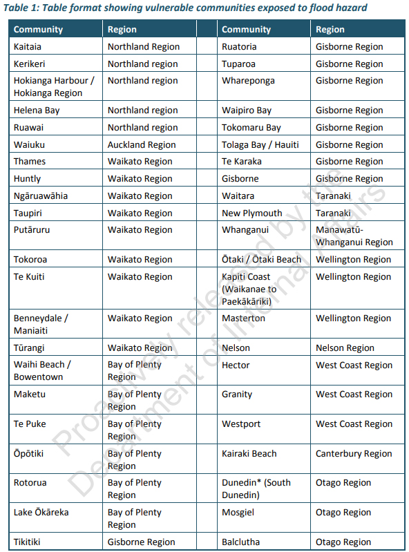
The Department of Internal Affairs (DIA) is highlighting 44 lower socio-economic communities around New Zealand that are exposed to flooding risk.
The DIA identifies these in a report, released by Associate Minister of Local Government Kieran McAnulty, on Vulnerable Communities Exposed to Flood Hazard. (See the full list of the communities at the foot of this article).
These communities aren't planning to build flood protection infrastructure according to council Long-Term Plans (LTPs), and communities in the wider district may have limited financial capacity to fund responses to flood risk.
DIA says the purpose of the report is to provide detail on how many communities are experiencing a relatively high level of socio-economic vulnerability, potential exposure to flood hazard, a lack of flood risk reduction infrastructure, and potential constraints on wider district community ability to fund flood risk reduction.
The DIA report comes after the Government in August released NZ's first national adaptation plan, which aims to "build a climate resilient NZ," bringing government efforts to help to build climate resilience together in one place.
Through legislation the Government is aiming to address the complex issues associated with managed retreat, which aims to reduce or eliminate exposure to intolerable risk and enables the relocation of assets, activities and sites of significance away from areas at risk from climate change and natural hazards. This follows the drawn-out retreat from the Bay of Plenty town of Matatā after landslides caused by heavy rain.
The Ministry for the Environment and Treasury are to lead work on how NZ meets the costs of climate change and invests in resilience.
DIA initially identified 75 communities with both relatively high levels of socio-economic vulnerability and exposure to flood hazard. However this was reduced based on planned infrastructure for some communities. Other communities were excluded because in-depth analysis of surface flooding in heavily urbanised locations was excluded from the scope of the report.
Analysis indicates that 11 territorial authorities have a relatively high proportion of vulnerable communities exposed to flood hazard.
Seven of these territorial authorities have a significant proportion of their population in vulnerable communities which are potentially exposed to flood hazard. These seven territorial authorities are: South Waikato, Waitomo, Buller, Gisborne, Opotiki, Rotorua, and the Far North.
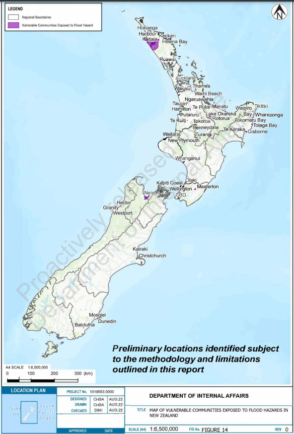
More than half of the vulnerable communities exposed to flood hazard are in the upper half of the North Island.
Vulnerable communities were identified using the NZ Index of Deprivation (NZDep 2018). The NZDep is an area-based measure of socioeconomic vulnerability in NZ.
To determine susceptibility to flood hazard the DIA worked with Tonkin + Taylor who incorporated input from NIWA and the Regional Council River Managers Special Interest Group to gather and analyse flood hazard and community vulnerability data.
The report considers “the financial capacity of the wider community within each territorial authority boundary as a proxy for the ability of that community to pay for responses to flood risk. Local communities, for the most part, fund the operations of a council mainly through rates, and through fees and charges associated with council activities.”
A range of potential criteria were considered to help understand the potential ability of the wider district community to fund any increase in payments to a council. The criteria included:
♦ The median household income.
♦ The percentage of people over the age of 65 as they are often superannuants and may be more likely to operate on fixed incomes.
♦ The percentage of people in the NZ Index of Deprivation decile 9 and 10 (most vulnerable).
4 Comments
Masterton is happily building on its flood prone areas. No worries!
From that table it looks like there should just be a general managed retreat from Gisborne and the West Coast.
Westport rebuilt flood damaged houses in exactly the same place.
Yes, but QBH built the house up 1m, so above the floods. Plus they are resilient to floods.
Tokoroa? Really? Having been there quite a lot, there aren't many rivers nearby. And water seems to disappear into the ground like nobodies business.
Looks like what I have been saying regarding climate change, the cost of road repairs and the likely prospect of having to abandon infrastructure as a result, is turning into reality. In an thread earlier in the year I was talking about how many Marlborough roads will simply be untenable to fix, too costly in terms of time/energy, just for you to have to fix them again the next year or next storm. Indeed, cycle touring the area at Easter and you could see the damage from flooding from years before was still being cleaned up, then they were hit with more storms. To fix them continually is quickly becoming untenable. Coming to a place near you:
https://www.rnz.co.nz/news/ldr/478035/some-marlborough-sounds-roads-no-…
We welcome your comments below. If you are not already registered, please register to comment
Remember we welcome robust, respectful and insightful debate. We don't welcome abusive or defamatory comments and will de-register those repeatedly making such comments. Our current comment policy is here.