
By Martin Brook*
Just over a month after the Auckland flood, and three weeks on from Cyclone Gabrielle hitting the North Island, the scale of the disasters and the rebuild is clear – as is a sense of being in limbo for those worst affected.
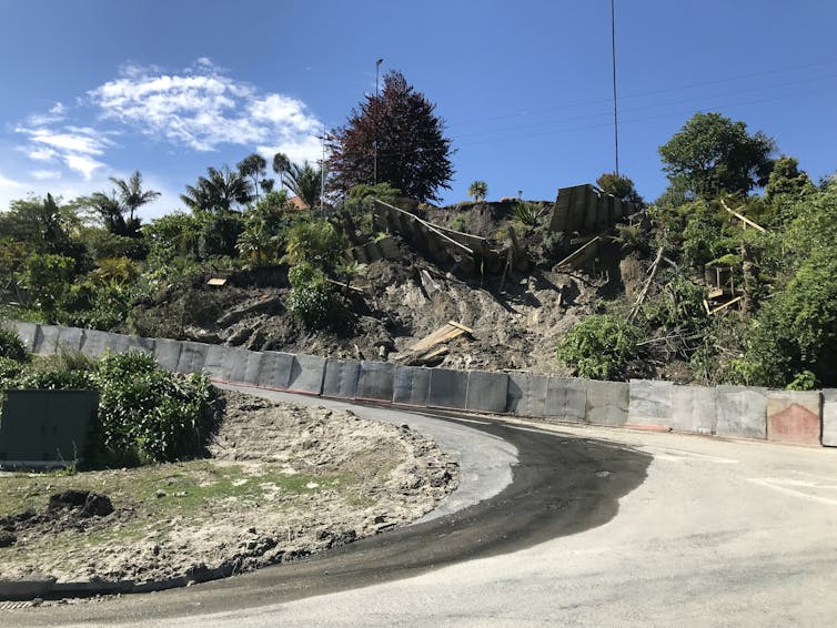
At Muriwai on Auckland’s west coast, locals were reportedly left frustrated by a lack of information after a community meeting called by Auckland Council last week. So far, 113 homes have been “red-stickered” in the small settlement, with another 75 along Domain Crescent yet to be assessed due to the street’s ongoing instability.
At the centre of it all sits section 124 of the New Zealand Building Act. This is the piece of law governing the red or yellow notices (“stickers”) pasted onto houses or buildings deemed “dangerous, affected, or insanitary”.
The situation now playing out at Muriwai provides a case study of the kinds of “pinch points” the use of section 124 can create for territorial authorities and their communities. The lessons learned should inform future disaster responses.

Listen to the science
Ultimately, councils want to keep people safe. But there can be tension when communities feel the risk from a hazard has diminished enough for them to return home and pick up their lives. Not least are concerns that a red sticker on the front of their house is an invitation to thieves.
Talk of “shutting the stable door once the horse has bolted” or “throwing the baby out with the bathwater” is often heard in the aftermath of a natural disaster. The storm has passed, the sun is shining and people want to return to what might seem a more benign environment.
But what is “safe” is vague, and everyone has their own interpretation of risk – including engineers. Some parts of Aotearoa recover faster than others, and councils have different ways of operating. So it’s important local authorities make balanced decisions by prioritising the science.
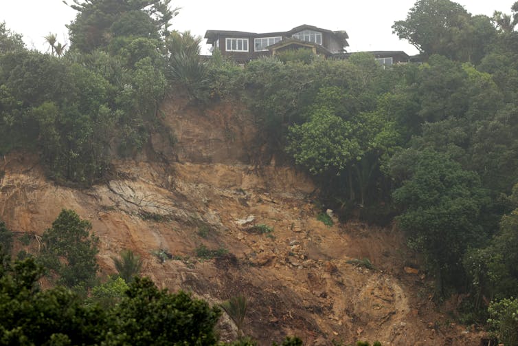
In Gisborne in November 2021, for example, widespread landslides occurred, including a substantial slip involving several residential streets. This transitioned into an earthflow, with the most mobile material probably characterised as mudflow.
Contractors quickly installed concrete blocks at the toe of the slope to stop any more debris sliding onto the road (see picture below). Disruption to the community was kept to a minimum.
Avoiding extremes
There are other examples, however, of government agencies and councils failing to keep people safe – or being over-zealous in their approach to hazard management and community safety.
Most infamously perhaps, in 1966 at Aberfan in South Wales a saturated pile of coal “spoil” slumped and flowed down the valley side. The result of no effective monitoring at all, the slide engulfed a primary school and killed 144, including 116 children.
Still in the UK but the other end of the scale, the Cumbria County Council acted very quickly in 2021 when cracks appeared in the soil at the end of a hot summer at Parton on the Cumbria coast. The council evacuated the village for more than a week, and the local school was only reopened 14 months later.
A klaxon warning alarm was installed as a precaution, but the geotechnical investigation showed there had actually been no recent movement of the slope at all. The “tension cracks” were more likely shrinkage cracks due to the soils drying out, not from tensional stresses within an unstable slope.
Both examples demonstrate the importance of understanding the true stability of a slope. Monitoring can be done by remote sensing from helicopter-borne LiDAR (as at Muriwai at present), or space-borne InSAR. But knowing what is happening to a slope means being able to see, in high resolution, its physical behaviour over time.
The technology exists
A good example of state-of-the-art monitoring is the ALERT system pioneered by the British Geological Survey at the Hollin Hill landslide test site in North Yorkshire. This uses ground surface markers, with a variety of motion and listening sensors installed below in geotechnical boreholes at different depths within the slope.
Monitoring moisture is often the key, as rising soil moisture is often the precursor to any measurable slope movement. The installed sensors stream data directly to a geologist’s office computer, providing the basis for science-based decision-making.
The international mining industry has also pioneered the monitoring of unstable slopes within open-pit mines. A land-based radar unit is pointed at a slope and provides measurements in real time to a control room. Trigger levels are set so that movement beyond certain allowable thresholds raises an alarm and the pit floor is evacuated.
A classic example of its effectiveness is a landslide at Bingham Canyon Mine in Utah in 2013. When radar detected slope movement above the acceptable thresholds, more than 100 workers were evacuated. A 60 million cubic metre rock avalanche occurred the next day. It was the largest non-volcanic landslide recorded in the US, and no one was harmed.
Finding the balance
Getting the balance right isn’t easy. Councils struggle to keep communities safe (recognising there is no such thing as zero risk) while also involving those communities in key decisions. It’s a dilemma local authorities and government agencies wrestle with across most OECD countries.
An approach to planning and mitigation of hazards based on te ao Māori (the Māori world view) has been advocated, but it’s yet to be determined how this would play out across the Aotearoa’s varied communities and cultures.
But based on Muriwai’s experience, an agile and empathetic approach seems important. This would involve community participation in local hazard planning, coupled with rapid installation and application of state-of-the-art monitoring technology.
Anxious communities recovering from tragic events need to feel they are being listened to. Engaging them in the decision-making process – as well as demonstrating the science behind those decisions – is vital. This is especially so when people’s homes and lives depend on the application of section 124 of the Building Act.![]()
*Martin Brook, Associate Professor of Applied Geology, University of Auckland. This article is republished from The Conversation under a Creative Commons license. Read the original article.
28 Comments
"Ultimately, councils want to keep people safe."
I've tried having a conversation with an environmental planner on such subjects as Matata, but it's pointed out to me that the word "want" in sentences with council and safe in them needs to be replaced with a stronger word like required.
Situations like Matata and Muriwai current legislation doesn't allow for compromise or any talking it through. Councils are required to decide with no room for decent.
Ultimately councils want to cover their liabilities. After becoming the last man standing with leaky buildings most will go overboard to ensure this.
KK. And the huge cost of minimising these liabilities and resulting risk aversion is borne by all ratepayers. Limiting the last man standing rule in respect of housing materials compliance and natural hazards to the extent of a councils contribution where there is a systemic failure, would drive better quality risk appraisal/transfer processes when principals to construction contracts make their section purchases and contractor/supplier selections. Councils are effectively a big pocketed risk underwriter for shonky suppliers and contractors.
Can someone tell me what is the max that EQC will pay out for land/section if it is red zoned?
My understanding is it's 300k max from EQC. This is where it gets interesting. The flood effected home owners that want Auckland Council to buy them out at CV, will conflict with red sticker homes that would effectively get a raw deal, going down the red sticker path. Watch this space for fireworks.
well yes it will. 300k will not buy you another section to build on, potentially leaving those with a red sticker 100's out of pocket.
...and a very angry red face.
From what I've heard from W.Brown, he wants to explore preventative or resilience measures first, ie berms, stormwater channels etc etc, before even entertaining a buy up scheme, in which case they would probably just red sticker the flood areas to keep inline with the cliff top slip red sticker areas.
AKL council will be mindful of precedence. A concurrence of saturated ground and a significant EQ in Wellington would generate a very large number of red stickers. Ditto flood in south Dunedin. Invercargill 1984 with 5000 homes flooded. If Gabrielle is just a CC forerunner, councils would quickly go bust.
The $300,000 is in relation to your house itself, not the land. This amount increased from 1 October 2022, so the amount paid by the EQC will depend on when your private insurance policy renewed. If your insurance policy has renewed since 1 Oct it will be $300k, if it has not been renewed it will be $150K. The balance is covered by your private insurance company. The land is a separate calculation - for more details check out: https://www.eqc.govt.nz/what-we-do/what-youre-covered-for/
In the aftermath of the Canterbury EQ sequences the National government decided to purchase house properties that were red zoned and reverted to the most recent rateable valuations to base that on. Unfortunately because of a not unusual Christchurch City Council stuff up, those valuations were a year overdue. Because of that more than a few lost what was likely to them pro rata, an important amount of equity. Minister Brownlie justified this by submitting, that on the other hand, some would have made some money. Cold comfort for change for the former then.
Yep, but not really a parallel scenario with Gabrielle affected properties. In ChCh it was a crown decision to not repair infrastructure that triggered its red zone liability, not the direct operation of natural hazard caused damage. Many of the ChCh red zone properties were readily repairable.
S72 of NZBA was changed by MBIE in 2008, and now allows Councils to approve Building Consent for at-risk/hazardous land, which they purportedly do all the time, as long as the first property owner takes-on Council's liability. MBIE care about their liability, they purportedly don't give a s..t about property owner safety. EQC and Councils have done natural hazard studies for most-all Council (Territorial Authorities) districts. EQC and Councils ostensibly know how prone your house is to a natural hazard disaster. The elephant in the room is, both MBIE and EQC allegedly know (that if you unwittingly purchase a house located on land prone to a natural hazard disaster) your house will inevitably be destroyed by a natural hazard. In other words, both MBIE and EQC allegedly have and continue to purportedly knowingly/negligently allegedly put your family in harms-way; which allegedly is criminal negligence, wilful damage and possibly manslaughter. I suggest its time flood disaster victims banded together (and ask NZ to help crowd fund) and sue MBIE and EQC for full compensation and loss; plus apply to the Courts for civil prosecution of MBIE executive staff and every Minister that allowed MBIE to change S72-NZBA law in 2008 and those Ministers that have maintained S72 since: Plus apply to the Courts for Civil prosecution of all Ministers that have allowed EQC to allegedly self-deal by purportedly restrict pay-outs to 300k.
The other elephant in the room is, why hasn't the NZ Police charged those relevant MBIE and EQC staff and relevant NZ Government Ministers with alleged criminal wilful damage and possibly manslaughter, by now?
PS: After a natural disaster, what is 'safe' is purportedly principally decided by the Engineer's PI insurance, which is decided by their insurance company.
I can see this buck stopping with me.... a tax and rate payer.
So now we have to fix 3 waters, health, roading, power infrastructure , education, policing AND refund all the clowns who purchased by a river or on a cliff top all over NZ.
I hate to tell you this, but not even a wealth tax is going to pay for all that.
Lucky EQC has 7.2 Billion in reserves
Sorry 7.2 billion won't go very far for the whole of New Zealand. Meantime my EQC Premium has doubled to $300. 00 per year
A not insignificant section of NZ society live in flood prone areas because of economic necessity. Houses are cheap there for a reason but it's all they can afford. These people are not 'clowns'.
No where near as cheap as they should be.
Yep. Suspect it won't be too long before that becomes very apparent. Look at east ChCh to see how that plays out.
'unwittingly purchase a house (with) natural hazards' . Really ? It's not that hard to check these things out. Pay someone to do it if you're not personally able. Basic due diligence.
Look at a flood map, see how much of Auckland lies either in a flood plain or has an overland path running through it.
Now tell me where you propose we build the tens of thousands of houses you don't think should be there.
Just about all property in New Plymouth must fall under natural hazard. There's a dormant volcano close by. I seem to recall being asked by the house insurance sales person if I was aware of any natural hazards. I mentioned Mt Egmont. I think her answer was we know about that one.
50+ volcanoes in the Auckland field...supposedly dormant
It's return periods that insurers are most interested in. Mt Taranaki and the AKL volcano fields are long cycle hazards and thus not weighted in risk models so heavily. Floods and resulting land deformation are short cycle and rapidly compressing with climate change.
Yes volcanos don't go off every year right!.... MBIE could have said NO, go build your house on an engineered earth mound or on pile foundations above the flood level or we are not going to give you building consent; rather than allegedly deliberately facilitating people and property being put in harms way. If a pine slash log had just smashed your $1.5m house, and then Nash and Hipkins told you to go get in line for your 300k from EQC, you'red be pretty p...ed too.
So 30 - 50 yrs ago councils should have foreseen the combined effect of climate change and forestry slash practices and using their MK3 Nostradamus calculators identified sites that in the distant future would be flooded. That makes sense. Mandated finished floor level 1:100/200 yr flood rules are a reality in an increasing number of council areas. Gabrielle will add impetus to this. The market is devaluing climate exposed sites. Those combined effects will progressively drive the retreat that needs to happen.
The light at MBIE hasn't suddenly gone on! They are still applying S72 (of the Building Act), every day; purportedly allowing Councils to issue building consents for homes without liquefaction proof foundations on liquefaction prone ground. I.e. ostensibly all of the Kapiti Coast, lower Thames Valley... The "managed retreat" pile is growing with hundreds of building consents that allegedly put families in harms way, every day? Why hasn't the NZ Police charged MBIE executive staff, Nash and Nipkins with alleged criminal wilful damage and possibly manslaughter by now?
Don't disagree with you that change at MBIE & councils has been glacially slow. I'm reluctant to defend them because there's been too much 'hard basket' thinking in my view but when you look at the way residents have aggressively resisted hazard identification notices on titles it's not altogether surprising they are gun shy. Kapiti a notable example. Councils don't have the resources to combat affluent residents and litigious property developers. In ChCh a developer took on the council over a subdivision near the estuary. CCC argued it would fail in an EQ, the developer threw big money at it, appealed and won. Come the ChCh EQ and bingo, liquefaction central exactly as council predicted. Today, many millions of destroyed homes and dislocated lives later, it's reverted to grassland. As it should always have remained.
The physical outcome of Councils actions you describe above, ostensibly prove Councils are putting families in harms-way = allegedly negligence = purportedly wilful damage + possibly manslaughter. Every day MBIE allegedly is allowing building consents that purportedly add to these gigantic multi billion dollar disasters waiting to happen. Its that simple, there's no "hard basket".
We welcome your comments below. If you are not already registered, please register to comment
Remember we welcome robust, respectful and insightful debate. We don't welcome abusive or defamatory comments and will de-register those repeatedly making such comments. Our current comment policy is here.