
By David Norman and Shane Martin
• Housing affordability remains a challenge for many in Auckland. Land use regulations such as the Rural Urban Boundary (RUB) are often blamed.
• But until now, no studies had looked at whether the RUB distorts land markets.
• Pre-RUB studies also underestimated the cost of infrastructure to develop greenfield (or undeveloped) areas, and in some cases ignored the value of location or mis-attributed amenity value.
• Our reviewed analysis shows the RUB accounts for at most between 0.6% and 5.2% of the price of the average developed residential property that has land and is inside the RUB.
• But market prices do not include the social impacts of more expansive development on things like congestion, emissions, viability of public transport and optimal use of existing infrastructure.
• We should evaluate whether these social impacts justify the RUB before bold recommendations are made on the RUB’s future.
The RUB debate
With housing affordability still a challenge for many in Auckland, the finger of blame often points at land use rules, such as the old Metropolitan Urban Limit (MUL) or current RUB, both of which have limited development outside certain areas of the Auckland region. If a growth boundary results in a land price premium that materially increases the cost of housing, then given Auckland’s housing affordability challenge, there would be an argument for removing the boundary.
The facts of this matter are fundamental to the shape of Auckland in terms of its growth, infrastructure provision, and economic and social outcomes. This means any policy to contain or expand development should be based on even-handed, defensible evidence.
The view that the urban boundary imposes a substantial premium on land is universally based on studies done on the obsolete MUL. On 15 November 2016, Auckland’s Unitary Plan became operative, consolidating the different zoning rules in the various legacy plans of the councils that amalgamated to form the new Auckland Council in 2010. It replaced the MUL with the more flexible RUB, which includes around 30% more land.
The Unitary Plan was the biggest change in zoning rules in New Zealand’s history, and increased physical development capacity in urban areas by around two million dwellings. This is several times Auckland’s projected housing demand over the next 30 years. Within the RUB, allowance has been made for around 137,000 new homes in greenfield areas. These significant changes render previous studies on Auckland’s MUL obsolete.
As our full technical report points out here, previous studies also had a number of other limitations. They generally underestimated or ignored the cost of infrastructure to turn greenfield (undeveloped) areas into residential-ready areas. As a result, they overestimate any price premium on developed residential land.
One often-cited study, which estimated the cost of land use regulation under the MUL at up to 56% or $530,000 of the total price of an average property (not land) in Auckland, also excluded proximity to the CBD as a determinant of property values in Auckland. Yet practically every study that includes this variable finds that proximity (especially to the CBD and/or jobs) matters.
Previous studies have dealt with the value that amenities add to properties with varying accuracy and detail. One study accounted for amenities by using a dummy variable for each suburb, but then assigned the value of this variable to the cost of land use regulation. It effectively assumes the difference in land prices in Ponsonby, with its proximity to jobs, the water, hairdressers, supermarkets and coffee shops, and rural areas near Pukekohe is overwhelmingly the result of land use regulation. But land is not geographically identical. Location matters.
Other gaps in previous analysis that we wanted to overcome included:
• selecting an appropriate way to compare parcels of different land sizes inside and outside the RUB
• using real-world sales data rather than property valuations (to avoid modelling a model)
• accounting for net useable land when converting farm or lifestyle land into residential sized sections
• considering natural hazards such as risk of flooding in determining property values.
The question we posed
Put simply, we ask if converting farm or lifestyle-sized land outside the RUB into infrastructured residential sections similar to already developed land inside the RUB would deliver land to the market more cheaply. If there is a material premium on land inside the RUB, it would imply that the RUB is inflating land prices inside it.
We define the RUB factor as the share of the price of the average developed residential property that has land and is inside the RUB that is attributable to being inside the RUB, if any.
We provide a brief summary of our approach later in this article but recommend the interested reader tackle our full technical report. In short, we built a standard hedonic pricing econometric model to explain property prices as a function of the dwelling, land, and location. We gathered screeds of information about the nearly 37,000 farms, lifestyle blocks and residential properties with a land component that sold in and outside the RUB between 15 November 2016 and 31 March 2019. This allowed us to explain much of the variation in property prices depending on property characteristics and location.
What we found
Our goal was to isolate the un-amenitied, a-spatial value of land in farm sized (four hectares or bigger) and lifestyle sized (0.4 to four hectares) land outside the RUB, and compare it to the un-amenitied, a-spatial value of developed residential land inside the RUB (less than 4,000 m2 in size).
The “un-amenitied, a-spatial land” value is what remains once we strip out other things that add value to property (such as proximity to jobs, the water, parks, or “good” schools; or the size and condition of the house, views, and contours of the land). We then estimate the value of un-amenitied, a-spatial farm or lifestyle land outside the RUB of the same size as the average developed residential property inside the RUB (618.7 m2 ) without these confounding factors. Here’s what we found.
Figure 1
Un-amenitied, a-spatial value of 618.7 m2 of land, before accounting for net usable land and infrastructure
| Farm-sized | Lifestyle-sized | Residential-sized | |
| Outside RUB | $1,069 | $7,447 | $67,164 |
| Inside RUB, Inside FUZ | $21,594 | $28,695 | $99,203 |
| Inside RUB. already developed areas | $70,098 | #37,000 | $132,665 |
This figure does not say that the average residential section in Auckland costs $132,665. It says that once you have removed almost everything that adds value to a property – its dwelling, its location and amenities, and other characteristics of the land – this is left over. The figure for farm-sized land outside the RUB is $1,069.
But it would be a mistake to stop the analysis here.
First, when farm or lifestyle-sized land is converted to residential use, a large share of that land will be converted into roads, stormwater run-off, parks and other uses from which no financial return will be made by the developer. This means the value per square metre of raw land needs to be adjusted upward based on an assumption about how much of the land will be used for non-recoverable purposes once converted to residential use. Recent Auckland structure plans suggest around 57% of land becomes unavailable, meaning the cost of the land must be recovered from the remaining 43%. To err on the side of conservatism (i.e. overestimating the RUB factor, if any), we assume 65% of farm and lifestyle sized land is available for cost recovery.
Second, and far more importantly to the results, the major difference between farm and lifestyle land on the one hand and developed residential land on the other is access to infrastructure – running water, flushing toilets, roads, power and the like. It stands to reason that the cost and value of that infrastructure would add massively to the value of land. Yet only one previous study we know of in New Zealand has made an explicit attempt to account for some of these infrastructure costs.
Figure 2
RUB factor using various infrastructure cost scenarios
| Property location | Higher estimate of bulk infrastructure costs |
Average estimate of bulk infrastructure costs |
Average estimate of bulk infrastructure costs, 15% of subsidy priced into land |
Average estimate of bulk infrastructure costs, 30% of subsidy priced into land |
Lower estimate of bulk infrastructure costs |
No allowance for infrastructure costs |
| Farm sized land outside RUB | -$77,580 (-8.1%) |
$15,820 (1.6%) |
$27,220 (2.8%) |
$50,380 (5.2%) |
$58,420 (6.1%) |
$131,020 (13.7%) |
| Lifestyle sized land outside RUB | -$87,391 (-9.1%) |
$6,008 (0.6%) |
$17,408 (1.8%) |
$40,568 (4.2%) |
$48,606 (5.1%) |
$121,208 (12.6) |
The Future Urban Land Supply Strategy (FULSS), which sets out the sequencing for an estimated 137,000 new dwellings in greenfield parts of Auckland inside the RUB, provides an insight into the likely bulk infrastructure costs. Our full technical report provides detail on how this work was used to estimate the cost per dwelling in greenfield developments outside the RUB. For a number of reasons we list there, the estimates we use for bulk infrastructure in this analysis are likely to be far lower than would be the case outside the RUB, but again, we err on the side of conservatism.
The cost for bulk infrastructure, notwithstanding they are lowball estimates, is eye-watering, ranging from $72,600 to $208,600 per dwelling. The average estimate per dwelling inside the FULSS area is $115,200. We would also note that even these figures do not include all of the infrastructure provided by central government or other costs of subdivision, including surveying, resource consent, legal and Land Information New Zealand fees that would be incurred in cutting up a farm or lifestyle land into residentially-sized sections.
Applying six different estimates of the possible cost of bulk infrastructure to develop farm and lifestyle land outside the RUB into useable developed residential properties similar to those inside the RUB, yields the RUB factors in Figure 2. The most defensible upperbound estimates of the RUB factor are in the dark grey boxes. We have pointed out the absurdity of a view that no infrastructure costs should be allowed for, but present that result too for the sake of completeness.
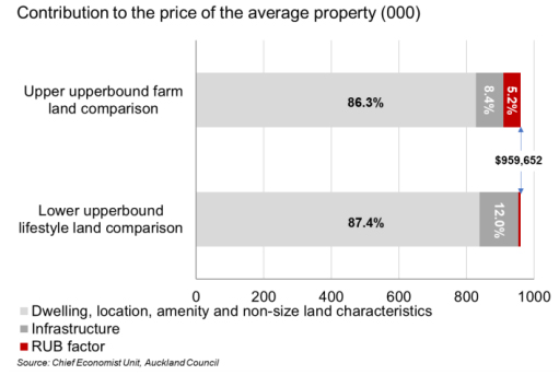
The most likely upperbound range of values for the RUB factor is 0.6% to 5.2% of the value of the average developed residential property with land inside the RUB (value of $960,000). We label this an upperbound range in large part because of the low estimates of infrastructure we have used throughout, and our exclusion of other subdivision costs altogether.
We ran numerous sensitivity tests on different model specifications, many at the suggestion of our external reviewers. None of the tests changed the modelled results in either direction by more than a few percentage points.
This last point is important. At higher infrastructure cost estimates, or different model specifications, it is possible that properties outside the RUB actually carry a premium. This would likely be because often two-thirds or more of the cost of bulk network and social infrastructure in greenfield areas is not borne by the property developer. Assumptions that this will continue to be the case may be encouraging land prices to be bid up outside the RUB, with the anticipation that the RUB might expand or disappear altogether.
What does all this mean?
Our analysis shows that the RUB factor, if any, is massively lower than previous work on the MUL had suggested. The reality of what the Unitary Plan has seemingly done to land markets, and accounting better for infrastructure and amenities matters significantly to how we think about the impact of the RUB.
Figure 3
Role of the RUB factor in the price of the average property
What about the social costs of sprawl?
Further, market prices do not include the relative social impacts of more expansive development on congestion, emissions, viability of public transport and optimal use of existing infrastructure, for instance. Our work provides a starting point for an informed debate on whether a RUB factor of up to 5.2% is justified given the social costs that may be part of more expansive development that would come with relaxing or removing the RUB.
A thorough analysis of whether these social impacts justify the RUB should be completed before bold recommendations are made on the RUB’s future, given the impact keeping or removing the RUB has on the shape of New Zealand’s largest city, its infrastructure needs and community outcomes.
How we did it
The interested reader will want to read our full technical report. But in summary, we used hedonic price models with spatial error disturbances to explain prices in farm, lifestyle and residential properties. We tested numerous models, but settled on a three-model approach with separate models for farm, lifestyle and residential sized properties, all of the same specification. This allowed for different values to be placed on amenities or the value of an additional square metre of land by property size category.
We did not use a “difference in difference” modelling approach, as we were not asking how the RUB affects land market prices relative to the MUL, but rather how the land market operates today, since the Unitary Plan and RUB were introduced. Further, the results of a difference in difference analysis could almost certainly not be meaningfully interpreted. Land that was outside the MUL but is now in greenfield areas inside the RUB would be expected to increase in value given the promise of infrastructure, but how much would be largely a subjective interpretation.
We are confident in the reasonableness and explanatory power of our preferred model, but we ran numerous sensitivity tests. These tests included using spatial error and lag models; a number of different spatial weights; models with and without median income; with and without zoning; with and without additional RUB, or RUB and FUZ dummy variables; with different thresholds for setting size categories; using log forms for estimating the value of an additional square metre of land; using capital value instead of actual sale prices; and using one combined model instead of three.
* David Norman is chief economist at the Auckland Council. Shane Martin is a senior economist at Auckland Council. This article was first published here. It is here with permission.
We welcome your comments below. If you are not already registered, please register to comment
Remember we welcome robust, respectful and insightful debate. We don't welcome abusive or defamatory comments and will de-register those repeatedly making such comments. Our current comment policy is here.