By Timothy Welch*
We’ve built our cities to be vulnerable to – and exacerbate – major weather events such as the one we saw in Auckland on Friday. While almost no city in the world could fully escape the effects of four months’ worth of rain in 24 hours, there are many things that could have been done to avoid some of the worst impacts.
Buildings, streets and car parks are all impermeable surfaces. When it rains, the water rushes off these surfaces and into gutters. From the gutters, the water drains into a stormwater catch basin, through the stormwater network, and into streams and the sea.
Herein lies the problem. The more we build, the more stormwater we need to drain. Every new building or road replaces the planet’s natural stormwater system: plants and soil, and channels for runoff.
The network of pipes can only hold so much water before it is fully inundated and begins to flood. While every block typically has a catch basin or two, they can easily clog with leaves and other debris even before a storm hits. Add an abnormal amount of rainfall, and neighbourhood flooding is nearly guaranteed.
In just four hours, Auckland experienced more rain than it usually does in two Januarys. Here's the storm broken down by the numbers.
— 1News (@1NewsNZ) January 28, 2023
👉 https://t.co/mzaTJuB0lV pic.twitter.com/Qo8zYh8nN6
Flooding and contamination
Even if the way we’ve built our cities and the stormwater system could keep up with big storm events – to be clear, they cannot – the network of basins and pipes is aging. With age, the system’s capacity to capture stormwater significantly declines.
Modernising all the stormwater infrastructure will take decades and billions of dollars. This is what the contested Three Waters project is really all about, and we need to quickly get past the political sideshows it has inspired.
While the system ages and suffers from reduced capacity, it is also more prone to failure. It’s not uncommon to see news that stormwater has mixed with raw sewage. This is gross just to think about, but it gets worse.
Because stormwater is not treated, when it gets contaminated that dirty mixture drains into the water around our beaches. It’s why, after a storm, the SafeSwim map is covered in red “high risk” markers.
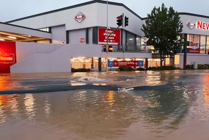
Roads become rivers
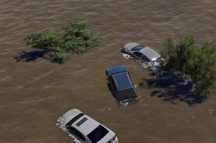
From Friday’s rain event, some of the most shocking images were of cars and buses trying to wade through flooded roads and busways. The irony is that the roads themselves are a significant contributor to the flooding.
With thousands of miles of sealed roads around Auckland, there was simply nowhere for the water to go. Roads act like channels, funnelling stormwater. With a huge rain event, streets quickly turn into rivers.
Setting aside the concoction of stormwater and raw sewage flowing down streets (which we more politely call a “combined sewer overflow”), and the impact on homes, businesses and beaches, flood waters also present a massive risk to people in cars.
It’s nearly impossible to tell how deep or fast surface flooding is, so people get into danger.
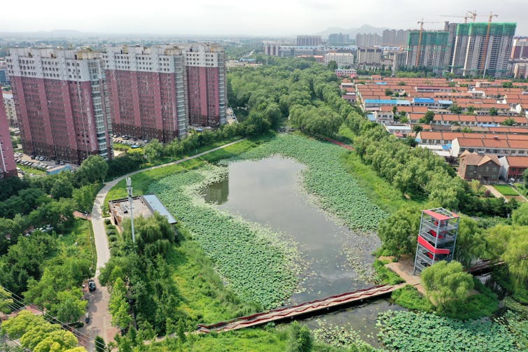
The ‘sponge city’
There is a better way to design our built environment. In the early 2000s, Chinese architect Kongjian Yu created the concept of the “sponge city”. It’s a relatively simple idea, but a big departure from the way we typically build infrastructure.
The concept incorporates green roofs, rain gardens and permeable pavements to absorb and filter water. Better catch systems hold rainwater where possible and reuse it. More green space and trees are also incorporated into street and neighbourhood designs.
Within the sponge city concept is a way to mitigate flooding using “water sensitive urban design”. With this approach, we create spaces that better manage flooding through systems that mimic the natural water cycle.
This can also include floodable infrastructure and parks to take the pressure off more vulnerable parts of the city. There are already examples of these design principles in Auckland, but they are far too limited to eliminate the impact of major storms.
Building smarter
The sponge city concept, and ideas about letting nature handle stormwater, don’t have to be extravagant or expensive. They can be as simple as planting more trees and greenery, using less pavement for driveways or more porous cement for car parks.
In a way, we should do less building and let nature do what it was meant to do.
The stark reality is the flooding we experienced this week, and arguably the storm itself, are of our own making. We’ve built a supercity covered in impervious surfaces, expanded the built environment across sensitive (and flood-prone) areas, and created massive greenhouse gas emissions destabilising the climate.
Climate change will make future storms more intense and more frequent. Do we cross our fingers and hope the rain goes away? Do we invest billions in bigger pipes that will inevitably fail to control flooding and still pollute sensitive waters? Or do we get smarter and more proactive about designing our cities?
If we don’t want to repeat recent events, there’s only one real option.![]()
*Timothy Welch, Senior Lecturer in Urban Planning, University of Auckland. This article is republished from The Conversation under a Creative Commons license. Read the original article.
63 Comments
Site coverage rules should have requirements around green space. Council seems to approve developments with just buildings and car park. Its terrible for neighbourhood amenity, let alone future flood risks.
Just like traffic, flooding needs to be managed. The answer is not to restrict development but to manage the flooding. Do we place a 10 lane highway in each direction to cater for peak traffic over Auckland harbour bridge? No, we bulid 3-5 lanes each way and just manage peak hour traffic and bear with some slow moving traffic for a short period of time during peak hr traffic. Just because we had 4 moths rainfall in 2 days, does not mean we rush to uproot all small pipes and replace them with huge ones. So stay focussed on the fact that what we experienced was likely a 1 in a 100 yr flooding event. Everday design caters for 1 in 10 or 20 or 50 yr event. Its fluid mechanics 101- flooding is not excess water, its the inability to have it discharged in a controlled manner and which can be enabled with sensible hydraulics/design.
Someone more mechanically minded might be able to clarify, but doesn't the effect of wide-scale flooding like this automatically mean the frequency of a similar or identical effect is drastically shortened and that run-off is now more likely to find the same places to flow through that it did on Friday? Meaning a '1 in 100' year flood may no longer require an event of that magnitude to generate the same outcomes?
They weren't built for 1 in 100 year events. But what you are missing there is climate change is making a 1 in 100 year event a 1 in a 2-5 year event and quickly. The upper South Island in the past few years has had multiple 1 in 100 year flood events. So uprooting small pipes and putting in bigger ones is what we must do as long as humans keep polluting, it is one part of the mitigation side of our response to climate change. Of course PDK would tell you that the replacement of the current infrastructure just for mitigation is also going to cause so much emissions, that at this point, it's pointless. Which is why it is more looking like system change is required (maybe more spread out or sponge cities), not just infrastructure change in existing ones.
This is incorrect. 1-100 year event does not literally mean a flood occurs every 1-100 years. Look it up.
I've assessed Victorian structures in flood plains all over the UK and looked at the original schematics that demonstrate that they were designed to withstand a 1-10,000 year event. Climate change had nothing to do with how Brunel designed his structures, he just built them to last.
We never touched or replaced them because they were designed so well, and these were 150+ year old Syphons, Culverts and reservoirs still in working order. The reason that the UK got wet 10 years ago was that Governments didn't pay to maintain and paid the price.
Best practice at present in the UK is to design to 1-1000 in a flood plain or at sea level. I work out of this field now but I'd be surprised if anything in Auckland is designed to that level.
You're likely right. I think the new Riverlink project in the Hutt is the design exception, not the rule;
“We are focused on saving lives and property from a one in a 440-year flooding event that has a 23 per cent chance of happening in the next 100 years,” the resource consent states.
Good article. 'As early as 1840, European settlers had a taste of how destructive the river could be when they initially congregated near the river mouth'.
I'm not an engineer and only ever built and repaired and upgraded flood protection assets but I can't really see how NZ even has the data to replicate a 1 in 1000-year event let alone predict how often they occur. Europe has pretty good data that goes as far back as the Roman Empire.
However, someone cleverer than me could probably answer that. What I do know is creating a sponge city is just a sticking plaster and does not address the real issue here.
Not sure what the district plan in Auckland is like, but other councils around the country typically cap site coverage at 30 - 35%.
In residential areas maybe, industrial and commercial areas are typically much higher
Not here in Mixed Suburban Zone, 60% maximum impervious area.
Actually Auckland Council and government removed any car park requirements so it is just wall to wall buildings. Hence not only is there no open space (not even to park a car or have a grass verge or green) but there is increased run off. Funnily though they still have trees that require maintenance in these areas but no plans for drain and storm water clearance regularly. After the massive floods though Auckland Transport finally got the drain cleaners out (even though residents have been complaining for years) sadly they should have been doing this regularly all along. Blocked stormwater drains are known for causing massive flooding and damage to surrounding houses; stormwater not designed for the capacity and population density is just as bad. I feel sorry for those in the poor areas of North and West Auckland. Auckland Transport have been snubbing them for more than a decade and the money for maintenance has been stolen for richer area beautification (the areas that don't usually flood anyway).
100% water sensitive design is absolutely necessary. But please don’t go parading such as a silver bullet solution for what we have just been through. Detention and soakage are great for lower intensity storms, but have negligible effect on the impacts of high intensity, long duration storms. If we do indeed have to cater for 300mm over 24 hrs w/ pre-soaking, we’ll need to adapt in other ways.
And he didn’t say it was a silver bullet. He openly acknowledged their limitations in a huge flood event like we just experienced.
I thought it was a good article, although the approaches are nothing novel. ‘Sponge City’ is a catchy concept, but everything it promotes has been around for decades.
Yet, we have a government that have introduced new mandatory planning rules that promote very high levels of hard and paved surfaces on sites - go figure!!!
There is a tradeoff, medium and high density development typically leads to a lot less area of hard surfaces per person. That does mean stormwater management in that area is more difficult, but there will be a smaller area that requires such management.
High density housing doesn’t *have* to mean little or no green surfaces on a site.
Especially if you can go to 5 levels or above, you can still require at least 30% of ground level to be permeable landscaped surface. And perhaps you can allow for taller building height if more of the site is landscaped eg. You can go to 6 levels if your landscaped ground cover goes from 30 to 40%. Ie. Go up rather than out
Singapore has done good approaches in both mandating and incentivising green surfaces.
I think in terms of this recent event it's possibly a little irrelevant re:site coverage, because once your aquifers fill you can have a lawn or a tiled patio and the waters not going anywhere.
It is the cumulative impacts at a catchment level. Ie. Lots of sites developed with lots of hard surfaces.
Pa1nter is somewhat right here. Impermeable surface area is a consideration for lesser events. For an event as extreme as this however, when the upper layers are already soaked: whether there was hotmix there or green grass will make little difference.
You can see this for example by the temporary new lake up at the Domain. That area is entirely grassed, but the underlying layers are already soaked, further restricting that collected water from percolating away.
This is why we're so concerned about this next rain band coming through.
One must acknowledge that SW flows will concentrate and travel downhill and allow for their passage.
Yep. But we will have more of the lesser events as well.
Tokyo takes it one step further. https://www.youtube.com/watch?v=Rp2l6nFIsZA
Semantics and he only acknowledges the limitations of our current built environment.
The titles 'How to avoid a repeat of Auckland's floods' + 'Auckland floods: Even stormwater reform won’t be enough – we need a ‘sponge city’ to avoid future disasters' and the conclusion 'If we don’t want to repeat recent events, there’s only one real option.' tell us us that only by following his design paradigm will we avoid a repeat.
I fully support greener design, but that article is misleading.
Yes, we can increase impermeable surface areas. However, you fail to acknowledge that we are also tasked with environmental mimicry, whereby we use detention etc as a means of reducing post-development average peak runoff to pre-development rates (for a reasonable range of design-level storms).
Again: if we are to expect 300mm in 24hrs, far beyond anything we would ever have considered, then society will need to better allow for, and adapt to the passage of consequential flooding.
Yes good points.
Yet I read an article from the BBC not long ago, naming Auckland as the spongiest city in the world. Go figure.
The author linked to that article in the opinion piece above as well. Not the best of supporting evidence :-). That's not to say there is not some merit in the design concept, but as explained by Befuddled above - the author ' over-sells' the concept in terms of its importance in the mix of necessary changes and upgrades.
These above ground initiatives do nothing to solve the below ground infrastructure issues that, for example lead to the mixing of storm and wastewater during flood events.
We will need to engineer our way through adaptation as much, if not more than, we design our way through it. The first up issue in this aftermath will be a question of re-build or re-locate/abandon.
Porirua City Council have put together a very good and equitable policy to my mind on 'managed retreat' from flood hazards in residential properties that have frequently flooded in these major weather events;
I've been quite surprised just how many of the recently affected residents have spoken about how they have experienced flooding and/or slips before. We have to find an equitable way to take them out of harms way in future.
Why do you think "we" have to find an equitable (= taxpayer / ratepayer funded) way to take them out of harms way in future ? These are private residential properties, thats why homeowners carry private insurance for their private risk.
For coastal properties which prompted Porirua councils ratepayers largesse in your link (dearest rates in Wgtn region), the risks of building on low lying land near the sea have been well known for millennia.
Most of the 40 properties identified as qualifying are inland - not coastal/beachfront.
'We' have to find equitable solutions because that is what a decent society does. Many of these properties are now unable to get private flood insurance and cannot meet the costs themselves of lifting the property to above the new 100-year flood level in order to get that insurance back.
It makes sense to me that the Council purchase them; affect the necessary building work; and then re-sell them on the open market.
The link says:
'The researchers calculated that 50% of Auckland’s surface was green or blue, even after excluding its harbours (London had the least of the seven cities, with 31%). In an intense rainfall event – 50mm falling in 24 hours – they estimated that 35% of the water falling on Auckland would be absorbed into these spongy blue and green parts, leaving 65% that would have to be dealt with by engineered stormwater systems – or else overflow and flood.'
Note to self, increase modeling from 50mm in 24 hours to 230mm.
.
You would certainly get a tiny improvement to stormwater handling by building up, using that vertical space but at the same time maintaining green space around each structure. More often sharing a wall with your neighbours, but with benefit of green bush, play and picnic space directly around your home, space that you just happen to share with 50 other units.
Sounds alright, right up until the KO tenants down on Level 2 turn the play and picnic space into their drinking spot. Box of beers, ciggies and a nice loud bluetooth stereo and off they go.
Straddling the 2nd story balustrade drinking Codys while their tribe of 6 or so sprogs run a muck in the communal greenspace.
On the North Shore many areas have clay. There is generally a small amount of topsoil on top which does absorb water a bit. To a point.
And when there is a development, if there is any topsoil, it is all taken away. Later, the permeable areas have things like pavers or pebbles put on them. Which are directly over the clay, so these areas do not act as a sponge one little bit! So the whole site is now essentially impervious. Ak unitary plan yey!
I get the green space ideal, but what about monsoon drains? I've seen these fill up while deployed with the Air Force in Malaysia. Very large quantities of water appear in a short time frame and are dealt with effectively in most cases. Down sides (they can fill with rubbish, but to some degree self-flushing), but a simple solution?
Turn all drains into wetlands. current practice is to restrict the flow of a drain to a channel in the middle that will flow with normal rain. It is then angled up from there to allow for heavy rain , then contained by a concrete wall or earthen stop bank. It has advantages, the normal flow channel keeps itself clear, the slopes are easy to build .
But there is no storage. and little wildlife. By increasing the normal water channel to a lot wider width , there is storage , and the initial rise in water level is less. In most of Auckland the path to asea is pretty short , so even that initial higher capacity will help a lot.
Except in the locations that flooded they are mostly clay. Protip you essentially are going to have floods in residential areas if you think clay is effective for water absorption in the parks and wetlands. Did you miss the lesson in the past few days. YOU DO NOT DRAIN WATER THROUGH CLAY.
Wetlands do not drain into clay, they store water, and allow a large, wide water level area to drain to sea. In some areas , it may be necessary to seal the bottom with something like Bentonite to stop them draining in dry weather.
Just like during COVID times, solutions offered by the private sector completely ignored.
https://www.nzherald.co.nz/nz/we-can-make-500-sandbags-an-hour-small-bu…
Ambulance at the bottom of the cliff.
"we can produce 500 an hour"
And what rate can you produce them when your staff can't get back to the factory?
And how long does it take to distriubute them when the roads are all flooded?
You'd need a large network of local neighbourhood pickup sites with existing stockpiles.
Reality is nothing in terms of existing infrastructure is going to change, if the council cannot even get round to cleaning out existing drains there is no hope. Perhaps going forward we can quit building new houses in low lying flood prone areas and upgrade the current plans to cope with more stormwater. People buying a house in Auckland need to look at the surrounding area now rather than just how nice the Kitchen is. Newer housing in the likes of Silverdale has water tanks in the ground that can remove peak flows, even bigger tanks would be better but this is all adding cost, however this cost suddenly pales in comparison to the cost of a civil emergency caused by flooding.
We have an 5,000 litre capacity stormwater soak pit, as well as connection to the main stormwater system (house built 2007, and it was required, along with the building platform being raised on solid ground above flood levels, not just piles) and it's staggering how quickly that pit filled up. So, yes, larger is better.
1 mm of rain over 1 square metre is a litre. So if you have a 500 m^2 section, 5000L is only 10mm of rain
The surrounding area on the day you buy your house is no assurance that the council won't allow massive levels of development around or uphill of you and turn your driveway into a whitewater rafting course with all the extra hard-surface run-off.
Some serious questions to be asked about why there is such massive intensity going in some parts of West Auckland around the areas of long-standing housing that suffered the most damage.
You don’t get it - higher density housing pretty much everywhere is a good thing…
It isn't going in 'pretty much everywhere'. It's going into the places where the land is cheapest, as it was predictably always going to go. The question is are those places also getting things like stormwater upgrades and support to deal with the extra run-off in those areas? My guess is 'no'.
Take it from someone who lives in the Massey/Westgate area - there's a level of development happening out here that most Aucklanders would struggle to understand unless they saw it. The development around Swanson Road is probably ideally placed in terms of being right next to the railway line and Sturges Road, but is the run-off from those developments being sufficiently considered on an accumulative basis?
As I mentioned previously, the RMA has been awful in terms of dealing with cumulative effects on the receiving environment.
You question is spot on GV.
There’s maps produced by the council that show its occurring widely throughout Auckland.
the new planning standards will only exacerbate that
It's more nuanced than that. Per person in low density has more surface hard area, but if that was spread over a far larger area to allow for the difference, then there would be no extra effect.
Also what is regarded as a permeable area is misleading in that once the machines have contoured land and compacted things done, man-made vegetated areas can be 10x harder and less absorbent than the natural ground. The higher the density the less permeable are the 'permeable' areas.
And then there is the topography and natural watershed areas.
In places in Taranaki, all they do is drill a soak pit of the end of the roof downpipe and all that water is absorbed as the soil is deep and is so friable.
Milford Sound does have much trouble shedding its water. The parts that can be are highly absorbable and the parts that shed the water are hard granite and move that water quicker than the fastest hydroslide.
Did not see any major flooding in Milldale or Millwater. Both are on reasonably rolling country with runoff.
Until only recently our biggest storms came from the SW in winter. Now summer based NE flows seem to cause the most damage. These NE atmospheric rivers seem very unpredictable re where they hit, how long they linger and how much rain falls in a short period of time.
Soak tanks will be overwhelmed with these events but clearly help during most weather events.
Skifields close and now Auckland floods. Emergency services must be very worried that the coming rain could be equal to the past episode.
The prevailing wind is from the sou-west but the biggest rainfall events have always come from the north-east.
Warmer air can carry more moisture, so you'd expect the most extreme rainfall events to be coming from the north
There's history. Hutt had up to 300mm rain in 24hrs in December 1976 (Auckland Friday 240mm) I remember wading through 1m water across Lower Hutt to get to work at Seaview, parents were cutoff for a week by a slip. Took a long while for the region to recover.
https://hwe.niwa.co.nz/event/December_1976_Wellington_Flooding#:~:text=….
Its the governments fault. They deliberately planned a City in the path of a raincloud, what were they thinking.
Er no but they deliberately set low building standards and increased density and councils deliberately cut maintenance from their budgets in favour of white elephants that mean any raincloud has an exponentially larger effect. While flooding in some areas has frequently happened the effect of higher density, no maintenance and no storm water upgrades and literally no heavy rainfall preparation in the years, weeks & days ahead, ALL leads to critical natural & built drainage system failure. Anyone who points out that the lack of critical infrastructure around higher density development and the council washing its hands in fixing and maintaining infrastructure there is immediately called a nimby or boomer (oddly with the ageism these days) even though this is a direct warning cry from residents who already experience flooding from even moderate storms due to the poor infrastructure and lack/or poor design of drainage systems in the area.
Yes, and all that you say can be done with a simple legislation upgrade, WITHOUT the need for the three waters command and control that the Govt. wants.
Our poor quality of housing is due to lower standards allowed by our building regulations.
If we want better buildings, set the regulation minimum for the level.
Same transport, waterways, etc., etc. and fund them properly with the likes of allowing municipal bonds etc.
The Govt. role is to introduce the proper legislation, and not get too involved. Otherwise, they will be as successful as Kiwibuild.
Don't forget we had the double whammy of high tide with record rain fall. Not sure any model predictions have those planned out to coincide together.
Hi Tim. It would be interesting to see the empirical evidence that future storms will be more intense and more frequent. I cannot find any on the link provided.
Auckland suffered the same fate as Brisbane in feb 2022. We got 676mm of rain in 3 days along with the king tide. Water got up to 3.7m level in our area. High Density development was part of the problem, water had no where to go and hardly any ground for it to soaked into.
Luckily, for us the State govt is paying us a grant of 100K to lift out house higher above all flood level, or 50K for refit our interior for flood resilient.
We have legacy colonial cities sprawled from where it was convenient for shipping at the time. In hindsight they are prone to the affects of climate change and seismic threats, why not just retire them.
It would be a hard argument to support that NZ will not have a population increase at a similar rate in the next 50yrs as we have had in the last 50. This would support the equivalent of at least 3 new cities of 500k. Built from scratch, in locations less affected by adverse events. Planned and confined in area and population, built in transit, few if any roads, optimized water and waste systems, low energy buildings to minimize the human footprint all without having to do any expensive upgrading of faded infrastructure.
Let the old cities quietly fade to quaint seaside tourist spots for the nostalgic.
The attached article does not cover NZ (I think we were too small) but it raises interesting questions related to this interest.co.nz article.
https://www.strongtowns.org/journal/2019/2/20/which-countries-have-the-…
If we are looking at possible solutions to Auckland's flooding problem, why not solve our land shortage as well?
Put a dyke across where the Harbour Bridge is now and drain the inner Waitemata. This will lower our water table to allow more inground storage for floods and provide land for additional housing close to the city.
Passing ownership of everything to do with water to Maori governance will not improve anything.
As Peter Williams aptly pointed out, the only requirement for staff in advertised vacancies was a knowledge of Te Reo Maori - that's all!! Engineering, no, or any other useful skill.
We welcome your comments below. If you are not already registered, please register to comment
Remember we welcome robust, respectful and insightful debate. We don't welcome abusive or defamatory comments and will de-register those repeatedly making such comments. Our current comment policy is here.