By Martin Brook*
The January 27 storm that hit Auckland broke all previous rainfall records and has caused widespread damage, mostly from flooding and landslides. But while climate change helps explain the intensity of the rainfall, the way land has been used and built on in the city is a major factor in what happened.
Such rainfall events generate significant landslides, probably in the thousands. What geologists refer to as “multiple-occurrence regional landslide events” (MORLEs) are sometimes also triggered by earthquakes (such as happened in Kaikoura in 2016).
But predicting where and when land might slide is not easy. Influencing factors include local geology, the properties of the slope material (soil and/or rock), slope geometry and angle, surface vegetation cover, drainage, and any buildings which can add weight and “load” to a slope.
Combinations of these factors were involved in Auckland, and understanding what happened and why will be important for ensuring the city is protected from similar events in future.
Weak saturated soil
Auckland has weak, clay-rich soils formed by the weathering of underlying (often) weak rocks. It also has a lot of steep slopes. Even in their natural state, these slopes can be prone to sliding if the soils become saturated enough.
A further issue is the seasonal drying and wetting of soils. Auckland’s clay-rich soils show high “shrink and swell” properties, meaning there is a natural annual cycle of wetting (swelling) and drying (shrinking).
This can cause a progressive weakening of the soils over years and decades, called “strain-softening” (a bit like taking a steel fork and bending it back and forth). The soil is then more prone to failure when a large rainfall event occurs.
In theory, then, more extreme climate effects could lead to an increased rate of soil deterioration, causing the properties of the soil to change more rapidly.
Rainfall “thresholds” are also important to consider. These are the rainfall totals – measured across either 24, 48 or 72 hour intervals – that can initiate landslides on a given slope. But using rainfall forecasts to predict landslides oversimplifies the issue because the prevailing (“antecedent”) soil moisture conditions are also important.
Soils are made of solids (the grains), water, and air which creates “pore” spaces. If it’s been a very wet few weeks preceding a storm event, water increases within the pores (“porewater”), creating an increase in pressure. This lowers the strength of the soil, meaning less rainfall may be required to trigger landslides.
Slips have left houses in West Auckland's Titirangi teetering on hillsides and some residents are still without power and water after Friday's deluge.https://t.co/wldAv8j1Vl
— RNZ (@radionz) January 31, 2023
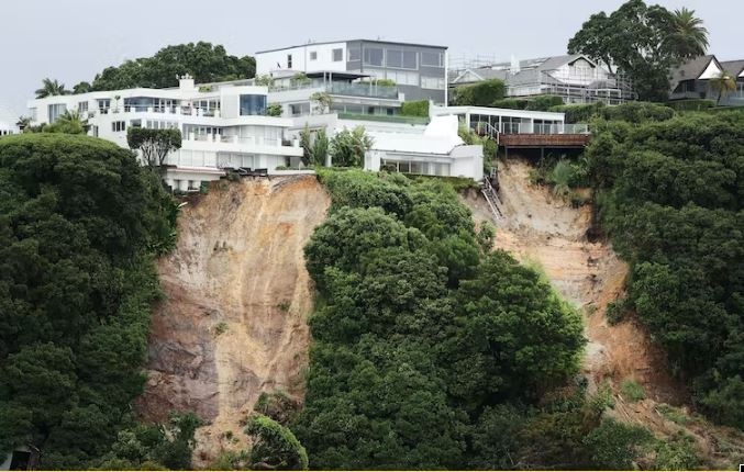
Too close to cliffs
While climate change and the warming of oceans that pump-prime extreme weather events are certainly pressing issues, changing land use is also of growing importance. Indeed, some studies now suggest it is as important as, or possibly exceeds, the effects of climate change on landslides.
These changes include the removal of vegetation, which allows more water to directly enter the soil; the creation of impermeable surfaces; and the cutting and filling of undulating slopes to enable roads and buildings to be constructed. All of these affect the near-surface drainage and hydrology.
A further problem in Auckland is often the lack of adequate building “set-back” distances. This is the distance between a dwelling and a slope or cliff edge. In some countries and jurisdictions this is specified within regional plans and taken very seriously.
One way used to calculate these distances is to project an imaginary 45 degree plane from the bottom of a slope. One third of the cliff height is then added to this. For example, a 30-metre high slope would have a set-back distance of 40 metres.
But local geology and climate is also important. With weak soils in a humid climate, a conservative rule of thumb could be a set-back distance of three times the height of the slope or cliff. So, a house on a 30-metre high North Shore cliff, with superb views across to Rangitoto Island, should be set-back around 100 metres from the cliff edge.
Yet there are many houses within just a few meters of cliff edges in parts of the North Shore and eastern Auckland. Swimming pools constructed on slopes can add to the loading and stress, making the slope more prone to failure during a significant rainfall event.
Set-back from the bottom of slopes is also important, because inundation (“runout”) from landslides on slopes above houses can occur, as witnessed in various parts of Auckland.
A neighbour describes what happened as a bach came down in a landslide in the Auckland township of Manukau Heads, injuring three holidaymakers. https://t.co/HNqte29Yre
— Stuff (@NZStuff) February 1, 2023
Three ways forward
Looking ahead, there are three broad approaches to mitigating rainfall-induced landslides in Auckland. First, it will be interesting to see how set-back distances are applied and whether changes to the Auckland Unitary Plan are made in light of recent events.
The Earthquake Commission (EQC) covers land within eight metres of homes and outbuildings. But many houses will now be much closer to the edge of properties. For houses still more than eight metres away from a failing slope, gradual slope creep may suggest future failure is only a matter of time.
Second, landowners should limit vegetation removal and make sure stormwater drains properly into reticulated systems, rather than informal soak-aways.
Any surface cracking or bulging, cracked masonry, or difficult-to-open doors or windows should be checked by a chartered engineer. This can be useful in determining what is generally benign (but annoying) seasonal cracking due to soil shrinkage, and what is more serious.
Third, for scientists, engineers and local authorities, a more sophisticated region-wide approach to identifying unstable land is needed. The Interferometric Synthetic Aperture Radar (InSAR) uses space-borne radar to measure ground surface movement at a scale of millimetres-per-year.
I led an EQC-funded team that successfully applied this technique to Gisborne from 2016 to 2021 using the European Space Agency’s Sentinel satellite constellation. This provides measurements every 12 days, with the raw data being free. It has proved very useful to Gisborne District Council in their planning and decision making.
In Europe, the EU-sponsored European Ground Motion Service displays almost real-time measurements of slope movements across the continent that anyone can access. Such a service would be useful across New Zealand – and the events in Auckland suggest this should be a priority.![]()
*Martin Brook, Associate Professor of Applied Geology, University of Auckland. This article is republished from The Conversation under a Creative Commons license. Read the original article.
82 Comments
"For houses still more than eight metres away from a failing slope, gradual slope creep may suggest future failure is only a matter of time."
Add in what are pretty regular shakes to the ground, like the 4.8 we had last week - when it was raining, and how can insurance rates not soar, if they are available at all? And when a house is uninsurable, its resale value drops to virtually $0, as the land beneath it becomes worthless.
How to stop it?? It's been a simple answer yesterday and today and will be tomorrow.
Stop building on clay hills and build better where the foundation are dug into the hard rock.
This logic has been known for generations but greed has killed any logic for our beautiful country.
A recently completed beachhaven cliff top home had 8 metre piles and ring beam. That level of engineering did not stop the land collapsing around it
"How to reduce, flooding and landslides?"
The answer is quite simple, upgrade all stormwater drains to be able to cope with 240mm rain / 24 hours = no more floods and, no more land erosion. People at the Council want you to believe it can't be done, that's not true, it's costly, but it can certainly be done!
The previous record was half.
What happens if future events are say, 360mm.
Nature is telling us something and we think we can outdo it.
Well humans have a history of coping with nature, from living in caves, the advent of fire to keep warm and cook food, to building basic huts, to better, stronger shelters, then the introduction of water supply, electricity, more recently WIFI, better building materials, double glazing etc...
When London built its sewers in Victorian times, they were eight times larger than required.
When Auckland built the pillars for the harbour bridge, they were more than double the strength required. Permitting the clip-ons.
Extrapolate Auckland's population growth. Since 1950 it has averaged 2.35% per year. So having grown from 312k in 1950 to 1,700k in 2022 it should be over 10 million in 2100. My grandchildren will be alive to appreciate that. Planners to plan accordingly.
I'd hope we don't end up extrapolate like that. I dont think it's that desirable. But point well made.
Usually the better cities need many more people than Auckland to work properly.
Cities are examples of the benefits of agglomeration. However Auckland is distinctive in being only slightly more productive (GDP per capita) than its surrounding areas. Cities such as Toulouse (500k), Frankfurt (800k), Edinburgh (550k) are more productive than Auckland despite smaller populations. Maybe because they have fewer traffic jams?
Assume you have a good idea for a new hi-tech business and you can site it anywhere. You would need a city to get easy access to lawyers, accountants, computer consultancies; pre-built offices and storage facilities. You would also look for quality of living to attract and keep the best staff so your city has to be safe, with inexpensive housing, good schools, minimal commuting issues and easy access to mountains, rivers and the sea. Where would you choose? Auckland??
Productivity is a pretty bad measure.
I was leaning more towards viability of public transport and efficient use of space.
On balance, cities in general aren't great for humans. Round everyone up then shove them in small boxes.
errrr Toulouse has Airbus and Frankfurt is the financial capital of Europe. Edinburgh is a financial centre as well, so maybe choose Leeds, Glasgow and Naples?
Leeds and Glasgow have over 1m so were not good examples of successful cities that are medium sized. Never been to Italy but Naples has 3m inhabitants - if it was smaller it could be compared with Auckland - no idea how it would stack up but doesn't it have a crime & corruption problem or is that my ill-informed prejudice?
Toulouse has a something and so does Frankfurt. Heidelburg is only 160k and was a lovely city for a tourist - no idea of its productivity but the locals looked well off.
10 million will not be anything to appreciate.
What it would be, if it happens, is just plain, downright foolish.
Basically, we have to stop breeding ourselves out of house and home
Apart from Africa everyone's doing the opposite of that.
And Africa's not far from catching up too.
The future is old people dying alone.
I'm cracking on, and frankly, death is going to come whether alone or not. To justify more and more people just to avoid that strikes me as pretty bananas, actually
Just pointing out that over population won't be a problem.
Future: old people having fun. There is no FOMO pressure when you are retired. NZ has set an example with its retirement villages - oodles of old people clustered together with shared facilities. Communal living - it is what radical students wanted in the sixties.
Or how most people used to live.
Exponential growth even at low % doesn’t last forever. The population of the world should be declining before 2100.
In some places way faster.
The birthrate in Sth Korea is .8
Japan and China are doing just that right now.
Happy with big rates increases?
That would need rates increased or 5 waters passed, ad we have heard the citizens say no.
Please stop - it hurts too much. Such a solution is just nonsense. We design drains for the 1-in-10 year storm event when overland flowpaths are available (so maybe 110mm over 24hrs) or the 1-in-50 year event for no OFP (maybe 150mm over 24hrs). Designing the primary piped system for 250-300mm over 24hrs (Albert Park figures had 211mm over 6 hrs!!) with the surface layers already waterlogged (so no soakage - runoff near 100%) is not at all practical.
What we do need to do, is ensure we have admissible overland flow paths - and perhaps even secondary flowpaths for more intense / longer duration period events - all of which requires deeper consideration and better planning responses, including water sensitive design and not erecting structures in flood plains / OFP's. We also want to slow the water down - the idea of using drains to speed up its passage is old school.
Most people here hate the concept of ‘planning’ and the idea that we could plan and design for better cities and environments, and invest as required.
I often wondered why Bangkok has the worst traffic jams in the world. Then I heard they had employed British town planners.
They got that elevated toll road though.
Bangkok, Urban planning? Those British chaps must have been neck deep in Pat Phong planning other things..
British towns can be divided into two groups - the crappy ones and those with something special. The two groups reflect their finances during the 50s and 60s. Many of the lovely heritage areas were about to be demolished but until the council ran out of money. Looking for decent public buildings try Glasgow or Halifax but avoid Reading or Basingstoke.
For the extreme example compare the Walthamstow Palace with its replacement or even its replacements replacement.
Auckland CBD is not an advert for fine historic buildings either.
Ngutoroa and Yvil,
You both say it is "simple" to fix, but clearly it's not. If we hadn't built on the clay rich hills where would those houses have gone? What problems would that have caused?
As for upgrading all the drains in Auckland to cope with relatively rare dumpjngs of rain... firstly, who is going to pay for that? And secondly imagine the disruption as all the roads in Auckland are dug up to do it.
Silver bullets are rare...and generally lurking somehwere is an unthought of/unintended consequence
Its only been "Rare" up until this point of time and a couple of weeks ago it never even existed. What if this eventually turns into an annual event ? Someone should do the math, even if this is even a 1 in 10 year event now it could be cheaper to fix the problem than to cross your fingers and hope.
FE, I'm certainly not saying "it's easy to fix", I said the answer is simple, which is very different, butI agree upgrading the stormwater system throughout Auckland is not simple, morisot cheap.
Whatever, most of the worst affected properties were built or bought into by affluent folk wishing to make a statement about that affluence to the other affluent. The 'million dollar view' crowd, already asking who will cover the loss as if their own risk should have been nil despite now decades of warning.
The simplest solution? Abandon our old, worn out, sprawled colonial port cities and build some compact modern ones in places of limited seismic, volcanic and flood risks in anticipation of a pretty certain future of population growth.
Excellent article thank you.
Council/Government won't want to hear about minimum set-back in the unitary plan when intensification is their objective.
Yes it is a good article except:
"....Second, landowners should limit vegetation removal...."
Depends. I have been on the water and seen the slips around the North Shore. Where most of these slips have occurred, there is now a huge Pohutakawa in the sea. These trees tend to grow horizontal on cliff faces so they act like a fulcrum bringing the cliff down. Especially the clay part at the top of the cliffs. The sandstone below is still intact.
The Council has resisted the removal of these large trees so is complicit.
Sure shrubs and ground cover such as kikuyu grass would perform as the author suggests. Not pohutukawa.
When I was a kid I lived in Malaysia early 1960's. The drain across the street was an open concrete drain 4 feet wide and 5 feet deep to handle the high monsoon rain. I remember standing in a main street in Singapore under a heavy down poor that flooded the street 6 inches deep. Half an hour later it was all gone and everybody carried on as if nothing had happened. My Auckland property flooded last Friday and again earlier this week. Its situated near the top of the storm water system but on a natural water course and 5 m below a 10,000 m2 playing field. Its been fine for 25 years with occasional run off from the field but never really a problem. New 315 mm storm water drain and a grated manhole in the middle of the driveway a couple of years ago. The drain system was incapable of handling the volume. The Auckland storm water system just isn't adequate enough to cope with this type of event and it will happen again with certainty.
Let's see if anyone in Auckland will build a house on top of sand?
Are people really that thick or don't they care? They just want something that looks nice and expensive.
Too many dollars and not enough sense.
What is the effect of the large unpruned overhanging trees at the top of these slopes that have slipped?
Seems to me the leverage of those trees must have some impact.
The trees themselves locally stabilize the slopes into which they are anchored. The problem becomes when (for whatever reason) the slope below becomes scoured out, creating a cantilever. When the tree comes down, it tends to end up being far more catastrophic, as it pulls a large chunk of bank with it.
A solution, would be to enable (or even require) property owners as-of-right to maintain and / or remediate such damaged slopes (prevent or reinstate lost downhill material) to mitigate the risk of such a catastrophic failure. Funny tho, whenever they get the quote, they all change their minds...
I am not so sure about the cause and effect.
The clean slopes the slips have left behind dont show much or any root penetration, and there was no sign of scouring prior to these slips.
Looking out my window I can see half a dozen slips and they all have a big fallen pohutakawa at the bottom.
Property owner would be the council as per the above post by someone else.
Look at the starting pic in the video. https://www.1news.co.nz/2023/02/03/slips-an-everyday-hazard-after-auckl…
THere is a clear pattern to the slips, and it's not the trees that are the problem.
Fundamentally this is a failure of this country’s political economy, and it comes back to our self centred, short term-ist mindset.
Everyone whinges when an earthquake or a flood devastates places in NZ, but everyone also whinges about paying more rates and taxes.
personally I would happily pay more taxes and rates if I could see that it was meaningfully contributing to addressing our resilience to these events.
Rates are a real problem. Too difficult to put them up because low income earners (mainly old people) can’t afford it. Our household pays almost 20x the amount of tax as we do rates.
I’ve never understood why rates are not paid monthly! That simple change would make them more affordable to those who struggle to budget, which is a big percentage of households.
Surely there can be some form of exception for pensioners.
I agree about monthly payments. I would find it financially easier to pay rates 10-15% higher than now on a monthly basis rather than a few big chunks a year at the current level.
A lot of councils offer a monthly payment plan. If you are up to date with rates, the remainder of the year can be paid monthly. The downside is that it’s usually a Direct Debit and personally, I’m not a fan of giving any entity direct access to my bank account as it makes it very hard to cancel properly. I prefer Automatic Payments, but councils aren't on board with that.
Rates can be paid monthly. All you have to do is set up a monthly AP for the account details on your rates statement. The council just doesn't require you to pay the rates any more frequently than 4 x 3 monthly instalments.
In many of the photos I have seen of cliff-face slips with houses, the slips are directly below the houses while the vegetated areas don't have as many slips.
I have seen the result of a farm track having been dug along a hillside, water has pooled continuously on the horizontal plane of the new track over a period of time, the water has soaked into the hill over a period of time at this point and eventually water within the hill has increased the weight of the earth below the track to the point where the track has slipped away.
If it hadn't have rained so much the hillside would have drained to release the weight burden. If the track had been angled so that the water didn't pool there, that would have reduced the amount of water soaking into the ground.
I have a suspicion that too many horizontal planes allowing soakage around the houses on the cliff-face may be part of the reason that the soil in front of the house has become too heavy to stay in place. If I was a clifftop landowner I would be sloping the lawn, courtyards etc and making sure that any water running off the roof or concrete paving is not directed into an area where the water can pool and soak into the ground beneath the house.
Pohutukawa roots bind the soil. The weight of a tree on the land is of less concern than the internal weight of the earth under the soil. Pohutukawas and flaxes around a house act as binding agents and a sort of wetsuit against the rain. (Pohutukawas also frame the view from a house rather than obscuring the view, so rich people should stop resenting them)
There is a story about the early missonaries to Papua New Guinea - they told the locals that instead of having drains in their gardens that pointed directly down the slope they should angle them along the slope to conserve water. So in the rainy season the new style drains filled up with water, soaked the soil to the point where the whole hillside and garden collapsed down the hill. Then the locals went back to doing what they had been doing for the last 10,000 years.
I've also been told that the city of Auckland's drains can cope with the rainfall that falls directly on the Auckland area but engineers planning does not take account of the water shedding off areas outside the Auckland area. Sounds a bit odd to me so I don't know how accurate this statement would be.
Vegetated faces are more stable. You'd also likely find that the SW runoff from the house was being discharged into or onto the slope, immediately downhill, accelerating scouring of the slope face / pore water pressure causing additional instability. As water exerts the same pressure in all directions, you can imagine how bursting forces increase rapidly with depth. The behaviour of the soil can also change, leading to rotational failure.
The hill behind Shore Road has collapsed before (with an engineer riding his house to the bottom). That was caused by (from memory, a Public?) SW drain simply terminating, meaning the cliff became waterlogged. It'll be interesting to see if lawyers get involved in the latest, given this has been a known problem.
A great way provide additional slope stability, is ensure good drainage. One doesn't necessarily need to slope the surfaces, but water can be collected in cut-off drains, piped downhill and discharged well beyond the cliff toe, via an appropriate energy-dissipation mechanism (rock rip-rap).
And yes - slip scarps (aka 'sheep tracks') or vehicle tracks with inadequate provision to shed run-off, means surface water enters thru those cracks and generates slope movement over time.
I think it was the houses anywhere near a creek that got the worst of it. The little creek nearish us became a full on river. Pretty easy to fix I would say, dig them deeper and or wider and put in a concrete base. Should cost millions not billions.
:-| Please stick to your day job.
If I told my boss at my “day job” that it would take 100s of billions of dollars to fix something it wouldn’t go unquestioned. But when it comes to council, getting a digger in to widen a creek requires 100 of planners and engineers and project managers.
It’s very ironic and funny hearing all the right wingers like Christine Fletcher and the NZ Herald (editorial) talking about the need for better planning, more investment into infrastructure, And more planting throughout developments and public spaces.
The right has been dismissing all these things for decades. Although to be fair, so has Labour…
It‘s all been about deregulating and saving pennies rather than investing. Oh well, this is what comes from that…
The right wings idea of better planning is just urban sprawl. That’s the problem with Auckland, way too much land area to possibly maintain or improve. If Auckland was a compact city it would be a lot easier. The central isthmus alone should be enough land area for everyone.
And then many on the left think the solution is density everywhere. Which is nearly as bad as sprawl. As it will just result in more increasingly congested roads = more pollution and CO2 emissions and less productivity
The idea is that dense housing suits public transport, so you end up with less traffic.
The idea is you do concentrated density near train stations.
Not medium-high density all over the place, as per the government’s mandate. That just results in more traffic congestion.
Christine Fletcher has been about long term planning as long as I’ve known her. She did sign off on Britomart with future proof capacity for it to be a throughway. Then along came John Banks who cut that from the plans, and ended up with a dead end station, leading to millions more to do the CRL.
Oh ok, I probably assumed too much, based on her centre-right leaning (which does not usually align with strong long term planning). So apologies to her
No one is all red or all blue, all left or all right. Human bias tends to simplify to us vs them arguments but real world people are incredibly grey matrix across many dimensions, not a straight line divided. Assuming the us vs them is what has lead us to the poor democracy systems that are little more than repeated us vs them battles rather than considered arguments. It is our own human bias and need for over simplification that harms us when it comes to planning for the benefit of future and multiple different diverse groups. Strategy that could work or with some adjustment work better for everyone is constantly fought in us vs them battles. Saying someone is right or left is not useful when those terms are just disparaging, even of good or useful ideas. The sad thing is that we need consensus rather than the two party system and even our "left" in NZ is very right of center.
Key in point most of those without insurance are those receiving benefits. Not once in history is benefit enough for essential insurance for 1 reason: Better to keep them in survival mode, too destitute to do anything than allow opportunity for stable life & upbringing. Place them in high risk housing if they are even lucky enough to get that so they will experience many trauma and tragedies. If they ever get out of survival mode they may actually have time & money to access medical care, to access submissions to council & voting, to access better work & higher education. Can't have that; Hence no benefit covers insurance & access to medical appointments and no support offers restitution for major lost possessions that are necessary for day to day living. Vulnerable people, especially the disabled families affected are told they should be begging for charity instead and frequently experience homelessness or dangerous unsafe living conditions.
Our "left" only increased the levels of destitution experienced and the "left" is completely alright with extreme human rights abuses that they themselves manage and increase because they view these people as not deserving of the same rights or not deserving close to a normal standard of living within a community. Sadly this is in every political party makeup in NZ. Hence while we don't have an actual left or right; we have political parties based on celebrity and distracting the populace with the constant us vs them battles as in 1984. Keep us distracted with political sport (and other sports)
I saw the name, and wondered if you'd somehow slip "people with disabilities" into your comment.
Over 1000 houses stickered. Where are all those people living? It’s not like Auckland has an abundance of spare housing is it?
Friends or family presumably.
Interesting read on one possible approach to storm water management.
https://www.iges.or.jp/sites/default/files/inline-files/04_DID%20Urban%…
Everyone has got all the answers, and what should of done now, but before the floods......
Stormwater problems have been boiling away for many years, and have been well known and documented.
Set back suggestion of 100m from a 30m cliff is almost certainly overkill for 50-100 year design life structures.
Why? When it's slides down the bank the current owner probably is asking questions.
Maybe we could get some dude to monitor unusual natural phenomena in our neighbourhood. Or just hire this ocker who called it in October 22.
"Chances are you remember the Tongan volcanic eruption – it was the most explosive since Krakatoa killed 36,000 people in 1883.
...The quantity of water in the stratosphere in the southern hemisphere has increased by about 20 per cent since the volcanic eruption.
...
Since mid-2020 we’ve been in three La Nina events and now this third one is being enhanced by the positive SAM, bringing consistent wetter than normal weather.
The more I look at this scenario, the more opposites I see.
The real problem we face right now is that we are facing a wet end to spring and a wet summer on wet or flooded catchments.
By the time we get to the end of summer I’m expecting this event to go down in the history books as the “Flooded Summer”
https://www.skynews.com.au/australia-news/how-a-tongan-volcanic-eruptio…
Soils that are rich in hydrating (swelling) clays (which are common in volcanic terranes) that are subjected to high water loading will create slope instability problems, just as Martin states here. However, most of the steep cliff collapses seen in Auckland last week occurred where trees growing near the cliff edges came down and brought the ground with them. In these instances, the over-stressed ground conditions simply could not support trees that had an added water load (therefore added weight) resulting from the excessive rain being held within their branches and leaf canopies. Perhaps in these situations there is a good argument to have mature trees growing near cliff edges removed rather than to suggest that vegetation will necessarily assist in stabilising a slope. However, each situation is always going to be different, depending on geology, topography and ground vegetation cover.
From slips I have observed its pretty simple. You do not need really heavy rain, you just need sustained rainfall until the soil reaches water capacity right down to the hard pan, hard substrate or rock. At this point the friction is reduced by water between the two surfaces and the soil above the hard layer must weigh twice what it normally does and bingo, the combined weight increase with the friction decrease it just lets go. Trees and vegetation can help with surface erosion but once it all gets to maximum water saturation its gone trees and all. You are looking at banks with a maximum angle of 45 degrees and retaining walls with extensive drainage before you can guarantee there will be no slips and guess what, its very expensive to engineer that correctly. When the wall costs more than the house, its time to build somewhere else.
The problem with that solution is that when you take the tree down the roots left behind die (taking large amounts of symbiotic fungi that hold the soil together with them) and shrink and create instability through channels where water can flow and by a lack of exudates that help hold the soil together...
Plus you take away a large canopy and get more surface erosion due to rain drops hitting bare soil
Still a long way off but this is not looking good (it's tracked closr and closer to NZ with each update...)
Edit: see below
Big rain coming for Wellington?
The forecast changed from when i posted. Originally it had heavy rain over auckland on tuesday.
Still quite a while to go but it looks like somewhere is going to get very wet next week, it's just a question of where exactly...
Unless I am reading it wrong, very low levels of rain on 14 February? Ie. Magenta equals 1-2mm?
Yeah sorry, i forgot the link is time stamped so it changes every time there's an update
Just click the link below and you'll see the forecats for the next 10 day (which just got worse again.,.)
https://metvuw.com/forecast/forecast.php?type=rain®ion=nzni&noofdays=10
No probs, thanks. Yes Auckland / Northland looks bad in a week but things could change.
We welcome your comments below. If you are not already registered, please register to comment
Remember we welcome robust, respectful and insightful debate. We don't welcome abusive or defamatory comments and will de-register those repeatedly making such comments. Our current comment policy is here.