By Stacy Vallis, Andrew Burgess, Ann Morrison, Imelda Piri & Priscila Besen*
With large parts of New Zealand having recently been pummelled by ex-tropical Cyclone Tam and ongoing bouts of heavy rain, it is important to remember that natural hazards have long shaped our cities.
Two townships in particular – Westport and Kumeū – have featured in national stories about floods since the 19th century.
They are now among a growing number of places where flooding infrastructure is losing effectiveness and drastic actions have to be considered, including managed retreat.
This raises understandable concerns about anticipated drops in land value and loss of social connection to a place. But managed or planned retreat is not a new concept nationally or globally. International examples can serve as useful references.
These stories from four communities in three countries show how connection to culture and place can be either challenged or sustained when relocation becomes necessary.
Tallangatta, Australia: six decades later
Back in 1956, the Australian township of Tallangatta in north-eastern Victoria was forced to move eight kilometres west because of the expansion of the Hume Weir.
Originally, “old” Tallangatta was located at the meeting point of the Mitta Mitta River and the Tallangatta Creek. But this was subsumed by a significant water-storage facility, the Hume Dam (Lake Hume).
During periods of low water levels, it is still possible to view the remains of the old town from a lookout.
About a hundred houses and a few shops were relocated, including some Victorian buildings. Residents said there was no cost to the relocation, with relocated houses repainted and given modern plumbing facilities that did not previously exist.
New public and commercial buildings were designed in the modernist architectural style of the era, and in 2016 Tallangatta was acknowledged as a “notable town” by the National Trust of Victoria.
The blend of Victorian and mid-century modernist buildings characterises the new township and represents different eras in its history, including the physical and social upheaval of relocation.
But while it can be possible to physically move timber buildings to a new site, characteristics such as original township layout and social connection to the surrounding landscape can be lost.
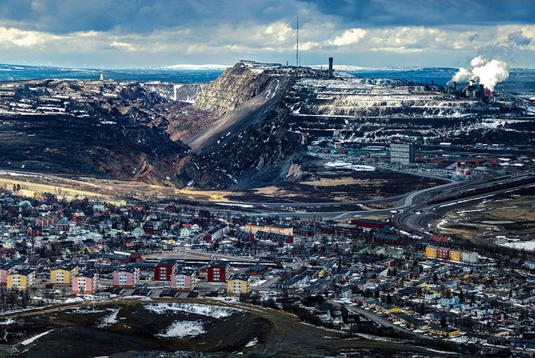
Kiruna, Sweden: cultural history, industrial growth
Sweden’s northernmost town of Kiruna faces a similar situation due to land subsidence caused by a huge iron ore mine. Its 18,000 inhabitants now have to move about three kilometres east.
The town’s rich cultural heritage includes a long Indigenous Sami history and a long period of industrial growth driven by the mine which saw it given national heritage recognition in the 1980s.
The relocation process has not been without its challenges. One big question was how many historic buildings to move to help retain authentic connections to place.
It was proposed that new building design would use the aesthetic qualities of the historic buildings. And there was discussion about either creating an “old town” within the site, or dispersing relocated buildings around the town.
Eventually, local representatives and the mining company (which funded the relocation) decided about 50 of the oldest buildings would be relocated while the remainder would be demolished.
Demolition has now taken place, along with construction of a new town hall to replace its predecessor, a heritage-listed building dating to 1964.
Such decisions call for careful balancing of the impacts on local Indigenous cultural heritage, the economic role the mine has played in the town’s expansion, and its contribution to iron production in Europe in general.
Parallel narratives: Westport and Kumeū
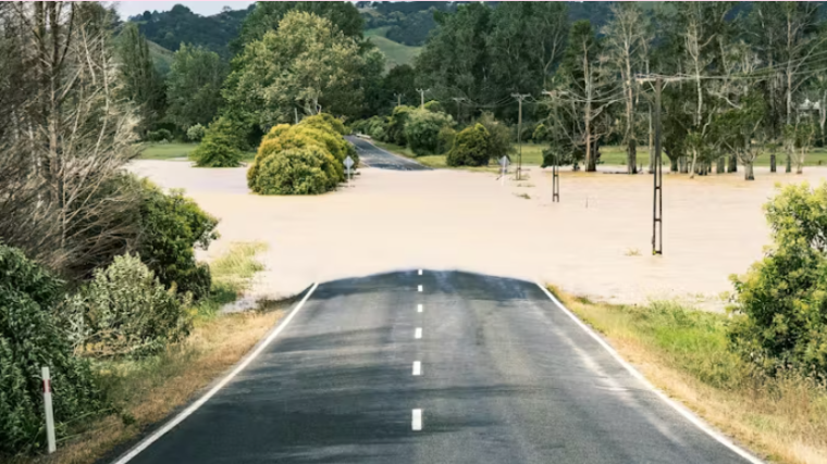
Climate change is making floods more intense and frequent. New Zealand’s South Island town of Westport is a 19th-century coal mining and trading settlement that experienced severe flooding in July 2021 and again in February 2022.
Although these floods were no larger than ones recorded in the past, their impact on homes and infrastructure was significantly greater due to Westport’s expansion over the years. The July 2021 flood damaged more than 500 houses, resulting in a NZ$54 million flood protection plan.
In 2023, the Buller District Council initiated a master plan to guide Westport’s future growth and development. It focuses on the controlled expansion of the township to higher ground on government-owned Pāmu farmland one kilometre southwest of Westport.
The council endorsed Westport’s master plan in March this year, but some residents are still apprehensive about the changes.
In the North Island, the township of Kumeū is close to Auckland, the country’s biggest city, but still reflects its farming history. Following recent floods, as well as several major floods since 1926, Auckland Council and local leaders joined forces to devise a plan to improve the town’s resilience.
While the prospect of managed retreat has been raised, proactive river maintenance seems the preferred option, including regular debris clearance by local contractors to optimise storm water drainage.
Managed retreat presents opportunities for improvement to Kumeū’s infrastructure. But the long-established cultural relationships between people and landscapes in Aotearoa New Zealand also need to inform inclusive decisions about major relocations.
Connection to heritage rests on relationships with place and setting. These can include buildings, landscapes and views, as well as the historical and cultural values associated with a given site.![]()
*Stacy Vallis, Lecturer in Architecture and Emerging Technologies, Auckland University of Technology; Andrew Burgess, Senior Lecturer in Architecture, Auckland University of Technology; Ann Morrison, Associate Professor in Interactive Design, Auckland University of Technology; Imelda Piri, Lecturer in Built Environments Engineering, Auckland University of Technology, and Priscila Besen, Lecturer in Sustainable Architecture, Auckland University of Technology
This article is republished from The Conversation under a Creative Commons license. Read the original article.
8 Comments
"Heritage" will spend any amount of other peoples money on vanity projects endorsed by their personal opinions. People seeking better & more secure lives have been adapting to relocation for millennia.
The choice of home/town location is usually based on convenience I'd wager with little to no recognition to geographic risks. It is only time and development that give the anchor to a specific site. In the modern materialistic world many individuals will be strongly tied to specific locations and upheaval can be traumatic and difficult.
I recently heard a youngish lady tell a group that she was living in a house her Great Grandfather built. I thought at the time that owing to the age, that her Great Grandfather chose a good location, and hoped that it was true. But ties to a plot of the whenua can run deep no matter who you are.
I recall reading somewhere years ago that European Villages built above the valley floor to save the fertile areas for farming. In NZ we chose to build on river valleys and coastal strips.
The above examples of Sweden and Aus were due to commercial activities and thus cost to relocate could (I presume) be part of the cost imposed on the project owners.
NZ scenarios don't have a party who are gaining to seek compensation/costs - only the public to tap.
Should those who chose the 'higher' ground be paying?
Managed retreat. End of the day you cant hold back the tide, or a flooded river - though stop banks are good until they are not. Look at the Tūtaekurī River from Cyclone Gabrielle, and the beachfront houses at Haumoana and Port Waikato to name a few. Such property is increasingly uninsurable = no mortgage, or are destroyed by severe events. Low lying exposed areas are increasingly on Council GIS and easy for punters to identify, and listed on LIMs as well. Buyer beware.
The real question is "who pays". Is it the owners problem, or is it a case of socialise the loss to rates, or Tax payers?
My 5c...its the owners.
My 5c is they ignore. The homes will become uninsurable, values will drop and each unsold for lower and lower to reflect the 'risk'. It will to the point last man standing will just walk away.
Process might take a decade or two, but ignore is an option - though for obvious reasons not publicly stated.
RE agents still talk up “absolute waterfront” and fools pay extra money to buy them
I don't think those that want to live on the waterfront are fools, but it needs a strong direction from government that there is no compensation for managed retreat from a coastal hazard - none. Buy it and enjoy it for as long as you can. If a wall is needed at some stage and the regulator allows for it to be built - then that's user pay. The Raumati South seawall at Kāpiti was built by the council and a targeted rate (targeted based on location) was charged annually against all properties adjacent to it, such that it was paid off by the owners (and successive owners) over a 30 year period.
There are solutions out there that have nothing to do with the taxpayer footing the bill.
Same could be true of an entire catchment that routinely floods and has been recorded as having done so for decades - targeted rates for out-of-the-norm mitigation costs, if they are viable - paid off over a 30-50 year period.
Flood protection of densely urban areas - such as Palmy North City - is charged on a proximity/location basis. If you move up on the hills around Palmy your flood protection rate is lower than if in the city centre.
GIS systems are so sophisticated these days - there are a myriad of possibilities to structure rates and charges fairly and equitably across any number of publicly provided assets.
We welcome your comments below. If you are not already registered, please register to comment
Remember we welcome robust, respectful and insightful debate. We don't welcome abusive or defamatory comments and will de-register those repeatedly making such comments. Our current comment policy is here.