
The latest census data suggests that not only has the number of new homes being built failed to keep up with population growth, but much of the new building activity hasn't happened where it is most needed, as developers concentrate their activities on wealthier suburbs where their margins will be greater, rather than poorer suburbs where the need is greatest.
The census data released this week by Statistics NZ shows that between the 2013 and 2018 censuses, the country's usually resident population increased by 10.8% while the total number of dwellings increased by just 6.2%.
That suggests a significant shortfall in housing compared to population growth. The table below gives those figures for all territorial authorities throughout the country and for the local board areas of Auckland Council.
They show there were wide variations in build rates versus population growth throughout the country but also that places where significant under building occurred were not confined to the main centres.
The shortfall between population growth and dwelling growth was greatest in Ruapehu District which was the only place in the country to record a small decline in the total number of dwellings.
After that, the area with the biggest shortfall was Opotiki on the east coast of the North Island, where the population grew by 10% over the five years between the 2013 and 2018 censuses but the number of dwellings grew by just 0.3%.
Or looking at it another way, only one new dwelling was built in Opotiki for every 70 people added to its population (the figure on the far right of the table below).
That was followed by Waitomo where just one new dwelling was added for every 22 new residents in the district, and Rangitikei where one new dwelling was added for every 17.7 new residents.
So it's not just the cities that are facing a housing shortfall, many country areas could also be feeling the squeeze.
In Auckland, where housing shortages have been most noticeable because of the sheer scale of migration-driven population growth, the region's population increased by 156,168 (11%) between the 2013 and 2018 censuses, but housing stock increased by just 6.5% over the same period.
And a look at the figures by Auckland's local board areas (at the bottom of the table below), shows that there was a much greater rate of housing growth in the wealthier parts of the city than in less wealthier parts where population growth was greater.
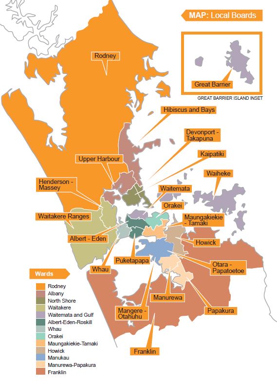
In the leafy streets of the Waitemata Board area, which includes the CBD and many of the city's wealthiest suburbs such as Ponsonby, Grey Lynn and Herne Bay (a map below the table shows the boundaries of all Auckland board areas), one new home was built for every 1.8 residents added to the area's population between censuses.
Other areas with high numbers of new homes compared to population growth were Waiheke (one new home for every 2.4 new residents), Upper Harbour (1:2.9) and Hibiscus and Bays (1:3).
But in the Otara-Paptoetoe board area, just one new dwelling was added for every 12.9 new residents and in Manurewa it was 1:12.6 and in Mangere-Otahuhu it was 1:11.8.
In fact more homes were added in the Devonport-Takapuna board area (660) between the censuses than were built in Mangere-Otahuhu (633), even though Mangere-Otahuhu's population increased by 7491 over that period and Devonport-Takapuna's increased by just 2505.
The comment stream on this story is now closed.
| Changes in Usually Resident Population Numbers and Total Dwelling Numbers Between 2013 and 2018 Censuses for all Territorial Authority and Auckland Local Board Areas | Number of people per dwelling 2018 census | Number of additional people per new dwelling 2013-2018 | ||||||
| Territorial Authority area | Population 2018 Census | Increase or decrease 2013–18 |
Dwellings 2018 census | Increase or decrease 2013–18 |
||||
| Number | % | Number | % | |||||
| Far North District | 65,250 | 9,516 | 17.1 | 29,472 | 2,037 | 7.4 | 2.2 | 4.7 |
| Whangarei District | 90,960 | 13,965 | 18.1 | 37,887 | 2,712 | 7.7 | 2.4 | 5.1 |
| Kaipara District | 22,869 | 3,906 | 20.6 | 12,030 | 1,203 | 11.1 | 1.9 | 3.2 |
| Auckland Region | 1,571,718 | 156,168 | 11.0 | 538,182 | 32,778 | 6.5 | 2.9 | 4.8 |
| Thames-Coromandel | 29,895 | 3,717 | 14.2 | 25,524 | 1,575 | 6.6 | 1.2 | 2.4 |
| Hauraki District | 20,022 | 2,214 | 12.4 | 9,228 | 504 | 5.8 | 2.2 | 4.4 |
| Waikato District | 75,618 | 12,240 | 19.3 | 27,675 | 3,117 | 12.7 | 2.7 | 3.9 |
| Matamata-Piako District | 34,404 | 2,868 | 9.1 | 13,845 | 654 | 5.0 | 2.5 | 4.4 |
| Hamilton City | 160,911 | 19,299 | 13.6 | 58,161 | 4,641 | 8.7 | 2.8 | 4.2 |
| Waipa District | 53,241 | 6,573 | 14.1 | 20,835 | 2,079 | 11.1 | 2.6 | 3.2 |
| Otorohanga District | 10,104 | 963 | 10.5 | 4,242 | 180 | 4.4 | 2.4 | 5.4 |
| South Waikato District | 24,042 | 1,971 | 8.9 | 9,675 | 216 | 2.3 | 2.5 | 9.1 |
| Waitomo District | 9,303 | 396 | 4.4 | 4,239 | 18 | 0.4 | 2.2 | 22.0 |
| Taupo District | 37,203 | 4,296 | 13.1 | 20,682 | 1,272 | 6.6 | 1.8 | 3.4 |
| Western Bay of Plenty | 51,321 | 7,629 | 17.5 | 22,041 | 2,007 | 10.0 | 2.3 | 3.8 |
| Tauranga City | 136,713 | 21,924 | 19.1 | 55,626 | 5,967 | 12.0 | 2.5 | 3.7 |
| Rotorua District | 71,877 | 6,597 | 10.1 | 28,464 | 1,017 | 3.7 | 2.5 | 6.5 |
| Whakatane District | 35,700 | 3,009 | 9.2 | 14,190 | 456 | 3.3 | 2.5 | 6.6 |
| Kawerau District | 7,146 | 783 | 12.3 | 2,733 | 45 | 1.7 | 2.6 | 17.4 |
| Opotiki District | 9,276 | 840 | 10.0 | 4,230 | 12 | 0.3 | 2.2 | 70.0 |
| Gisborne District | 47,517 | 3,864 | 8.9 | 18,435 | 510 | 2.8 | 2.6 | 7.6 |
| Wairoa District | 8,367 | 477 | 6.0 | 4,113 | 162 | 4.1 | 2.0 | 2.9 |
| Hastings District | 81,537 | 8,292 | 11.3 | 30,444 | 1,263 | 4.3 | 2.7 | 6.6 |
| Napier City | 62,241 | 5,001 | 8.7 | 25,215 | 591 | 2.4 | 2.5 | 8.5 |
| Central Hawke's Bay | 14,142 | 1,425 | 11.2 | 6,297 | 189 | 3.1 | 2.2 | 7.5 |
| New Plymouth District | 80,679 | 6,495 | 8.8 | 33,579 | 1,998 | 6.3 | 2.4 | 3.3 |
| Stratford District | 9,474 | 486 | 5.4 | 4,059 | 159 | 4.1 | 2.3 | 3.1 |
| South Taranaki | 27,534 | 954 | 3.6 | 11,958 | 273 | 2.3 | 2.3 | 3.5 |
| Ruapehu District | 12,309 | 465 | 3.9 | 7,011 | -57 | -0.8 | 1.8 | n/a |
| Whanganui District | 45,309 | 3,156 | 7.5 | 19,710 | 480 | 2.5 | 2.3 | 6.6 |
| Rangitikei District | 15,027 | 1,008 | 7.2 | 6,675 | 57 | 0.9 | 2.3 | 17.7 |
| Manawatu District | 30,165 | 2,706 | 9.9 | 12,282 | 705 | 6.1 | 2.5 | 3.8 |
| Palmerston North | 84,639 | 4,560 | 5.7 | 32,631 | 1,017 | 3.2 | 2.6 | 4.5 |
| Tararua District | 17,943 | 1,089 | 6.5 | 7,893 | 135 | 1.7 | 2.3 | 8.1 |
| Horowhenua District | 33,261 | 3,165 | 10.5 | 15,693 | 711 | 4.7 | 2.1 | 4.5 |
| Kapiti Coast District | 53,673 | 4,569 | 9.3 | 24,798 | 1,248 | 5.3 | 2.2 | 3.7 |
| Porirua City | 56,559 | 4,842 | 9.4 | 18,765 | 846 | 4.7 | 3.0 | 5.7 |
| Upper Hutt City | 43,980 | 3,801 | 9.5 | 16,710 | 771 | 4.8 | 2.6 | 4.9 |
| Lower Hutt City | 104,532 | 6,294 | 6.4 | 39,456 | 1,203 | 3.1 | 2.6 | 5.2 |
| Wellington City | 202,737 | 11,781 | 6.2 | 80,109 | 3,369 | 4.4 | 2.5 | 3.5 |
| Masterton District | 25,557 | 2,205 | 9.4 | 11,355 | 429 | 3.9 | 2.3 | 5.1 |
| Carterton District | 9,198 | 963 | 11.7 | 4,119 | 432 | 11.7 | 2.2 | 2.2 |
| South Wairarapa | 10,575 | 1,047 | 11.0 | 5,664 | 435 | 8.3 | 1.9 | 2.4 |
| Tasman District | 52,389 | 5,232 | 11.1 | 23,001 | 1,704 | 8.0 | 2.3 | 3.1 |
| Nelson City | 50,880 | 4,443 | 9.6 | 21,213 | 1,200 | 6.0 | 2.4 | 3.7 |
| Marlborough District | 47,340 | 3,924 | 9.0 | 22,149 | 249 | 1.1 | 2.1 | 15.8 |
| Kaikoura District | 3,912 | 360 | 10.1 | 2,220 | 138 | 6.6 | 1.8 | 2.6 |
| Buller District | 9,591 | -882 | -8.4 | 5,571 | 102 | 1.9 | 1.7 | -8.6 |
| Grey District | 13,344 | -27 | -0.2 | 6,537 | 168 | 2.6 | 2.0 | -0.2 |
| Westland District | 8,640 | 336 | 4.0 | 4,734 | 249 | 5.6 | 1.8 | 1.3 |
| Hurunui District | 12,558 | 1,029 | 8.9 | 6,720 | 489 | 7.8 | 1.9 | 2.1 |
| Waimakariri District | 59,502 | 9,513 | 19.0 | 23,454 | 3,150 | 15.5 | 2.5 | 3.0 |
| Christchurch City | 369,006 | 27,537 | 8.1 | 151,968 | 3,753 | 2.5 | 2.4 | 7.3 |
| Selwyn District | 60,561 | 15,966 | 35.8 | 22,677 | 6,015 | 36.1 | 2.7 | 2.7 |
| Ashburton District | 33,423 | 2,382 | 7.7 | 14,640 | 1,065 | 7.8 | 2.3 | 2.2 |
| Timaru District | 46,296 | 2,364 | 5.4 | 20,883 | 1,044 | 5.3 | 2.2 | 2.3 |
| Mackenzie District | 4,866 | 708 | 17.0 | 3,519 | 345 | 10.9 | 1.4 | 2.1 |
| Waimate District | 7,815 | 279 | 3.7 | 3,882 | 195 | 5.3 | 2.0 | 1.4 |
| Chatham Islands | 663 | 63 | 10.5 | 333 | 12 | 3.7 | 2.0 | 5.3 |
| Waitaki District | 22,308 | 1,479 | 7.1 | 11,400 | 597 | 5.5 | 2.0 | 2.5 |
| Central Otago District | 21,558 | 3,663 | 20.5 | 10,974 | 1,164 | 11.9 | 2.0 | 3.1 |
| Queenstown-Lakes | 39,153 | 10,929 | 38.7 | 19,140 | 3,483 | 22.2 | 2.0 | 3.1 |
| Dunedin City | 126,255 | 6,006 | 5.0 | 52,533 | 2,400 | 4.8 | 2.4 | 2.5 |
| Clutha District | 17,667 | 777 | 4.6 | 8,619 | 291 | 3.5 | 2.0 | 2.7 |
| Southland District | 30,864 | 1,251 | 4.2 | 15,210 | 627 | 4.3 | 2.0 | 2.0 |
| Gore District | 12,396 | 363 | 3.0 | 5,562 | 147 | 2.7 | 2.2 | 2.5 |
| Invercargill City | 54,204 | 2,508 | 4.9 | 23,055 | 600 | 2.7 | 2.4 | 4.2 |
| Total all TA areas | 4,699,719 | 457,719 | 10.8 | 1,855,929 | 108,603 | 6.2 | 2.5 | 4.2 |
| Auckland Local Board Areas | ||||||||
| Rodney | 66,417 | 11,535 | 21.0 | 27,357 | 2,973 | 12.2 | 2.4 | 3.9 |
| Hibiscus and Bays | 104,010 | 14,181 | 15.8 | 39,909 | 4,728 | 13.4 | 2.6 | 3.0 |
| Upper Harbour | 62,841 | 9,171 | 17.1 | 21,261 | 3,174 | 17.5 | 3.0 | 2.9 |
| Kaipatiki | 88,269 | 5,775 | 7.0 | 30,633 | 930 | 3.1 | 2.9 | 6.2 |
| Devonport-Takapuna | 57,975 | 2,505 | 4.5 | 22,485 | 660 | 3.0 | 2.6 | 3.8 |
| Henderson-Massey | 118,422 | 10,737 | 10.0 | 37,569 | 1,461 | 4.0 | 3.2 | 7.3 |
| Waitakere Ranges | 52,095 | 3,696 | 7.6 | 18,639 | 645 | 3.6 | 2.8 | 5.7 |
| Great Barrier | 936 | -3 | -0.3 | 1,125 | 174 | 18.3 | 0.8 | 0.0 |
| Waiheke | 9,063 | 723 | 8.7 | 5,862 | 303 | 5.5 | 1.5 | 2.4 |
| Waitemata | 82,866 | 5,730 | 7.4 | 39,162 | 3,192 | 8.9 | 2.1 | 1.8 |
| Whau | 79,356 | 6,762 | 9.3 | 26,031 | 921 | 3.7 | 3.0 | 7.3 |
| Albert-Eden | 98,622 | 3,927 | 4.1 | 34,278 | 480 | 1.4 | 2.9 | 8.2 |
| Puketapapa | 57,555 | 4,617 | 8.7 | 18,150 | 516 | 2.9 | 3.2 | 8.9 |
| Orakei | 84,318 | 4,779 | 6.0 | 32,445 | 1,323 | 4.3 | 2.6 | 3.6 |
| Maungakiekie-Tamaki | 76,284 | 6,279 | 9.0 | 25,881 | 525 | 2.1 | 2.9 | 12.0 |
| Howick | 140,970 | 13,845 | 10.9 | 45,921 | 3,015 | 7.0 | 3.1 | 4.6 |
| Mangere-Otahuhu | 78,450 | 7,491 | 10.6 | 18,900 | 633 | 3.5 | 4.2 | 11.8 |
| Otara-Papatoetoe | 85,122 | 9,459 | 12.5 | 21,606 | 732 | 3.5 | 3.9 | 12.9 |
| Manurewa | 95,670 | 13,428 | 16.3 | 24,819 | 1,062 | 4.5 | 3.9 | 12.6 |
| Papakura | 57,636 | 12,000 | 26.3 | 18,243 | 2,526 | 16.1 | 3.2 | 4.8 |
| Franklin | 74,838 | 9,519 | 14.6 | 27,897 | 2,817 | 11.2 | 2.7 | 3.4 |
Auckland Local Board Areas Map
*This article was first published in our email for paying subscribers. See here for more details and how to subscribe.
We welcome your comments below. If you are not already registered, please register to comment
Remember we welcome robust, respectful and insightful debate. We don't welcome abusive or defamatory comments and will de-register those repeatedly making such comments. Our current comment policy is here.