
Two counter stories about the growing sustainability of New Zealand hill country farms are being rolled out.
One is the great stewardship that is being done on farms and encouraged by such organisations such as Beef+Lamb NZ and Dairy NZ.
And the other, with less organisational support is a growing commentary about many of the unacceptable practices still being carried out on some New Zealand farms.
As a caveat to following, most occurred pre-Cyclone Gabrielle and it probably wouldn’t be fair to focus too much on the damage from hill country silt in this latest round. Many farmers who had invested considerable time, money and effort have seen their efforts washed away and potentially adding to the downstream problem.
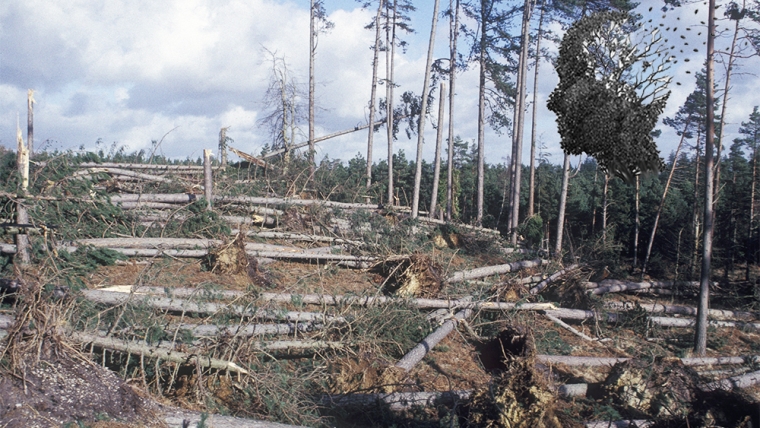
However, these farmers and land owners should also be asking questions of landowners upstream of them about how much they contributed to the underlying cause (too much water coming down too fast). Forestry’s part in this is a given. The evidence of their poor stewardship is everywhere to be seen and it is clear that the current (at least up to Cyclone Gabrielle) mode of operating is not sustainable.
But some quite extensive areas of pasture land are also being looked and the serious lack of tree cover has to be questioned.
Other aspects of land use, on hill country and flat land can also be scrutinised and found wanting.
So, with that in mind a scan of what was a reasonable definition of sustainable development was done. I believe it needs to be “sustainable development” as that includes social and economic aspects which a country needs to operate. Going back to a native bush covered landscape might sound attractive but it’s not really practical. The reasonably comprehensive definition below came from the Lincoln Institute of Land Policy (1999) and does include a hefty environmental component.
The principles are:
1) Work in harmony with nature. Land use and development activities should support the essential cycles and life support functions of ecosystems. Whenever possible, these activities should mimic ecosystem processes, rather than modify them to fit urban forms. These activities must respect and preserve biodiversity, as well as protect and restore essential ecosystem services that maintain water quality, reduce flooding, enhance sustainable resource development.
2) Liveable built environments. The location, shape, density, mix, proportion, and quality of development should enhance fit by creating physical spaces adapted to desired activities of inhabitants; encourage community cohesion by fostering accessibility among land uses; and support sense of place to ensure protection of special physical characteristics of urban forms that support community identity and attachment.
3) Place-based economy. A local economy should strive to operate within natural system limits. It should not cause deterioration of the natural resource base, which serves as a capital asset for future economic development. Essential products and processes of nature should be used no more quickly than nature can renew them. Waste discharges should occur no more quickly than nature can assimilate them. The local economy should also produce built environments that meet locally defined needs and aspirations. It should create diverse housing, and infrastructure that enhances community liveability and the efficiency of local economic activities.
4) Equity. Land use patterns should recognize and improve the conditions of low-income populations, and not deprive them with basic levels of environmental health and human dignity. Equitable access to social and economic resources is essential for eradicating poverty and in accounting for the needs of the least advantaged.
5) Polluters pay. Polluters (or culpable interests) that cause adverse community-wide impacts should be required to pay, taking into account that the polluter must bear the cost of pollution and other harms, with due regard to the public interest.
6) Responsible regionalism. Communities should not act in their own interests and should account for the consequences of their actions on others. Just as individual developers may be subject to the polluter (or culpable) pays, a local jurisdiction has an obligation to minimize the harm it imposes on other jurisdictions in pursuit of its own objectives.
The paper goes on to explain, principles one through four are associated with the “reproduction” characteristic, since they address the long-term ability of a community to sustain healthy local social, economic, and ecological systems. Principles five and six reflect the “link local to global concerns” characteristic, wherein communities (and individuals) act with a broader obligation to others.
With the now current acceptance that Cyclone Gabrielle and previous recent weather events are going to become more common, society is going to require more action be taken to mitigate such events, both at local and national levels. Nationally, that means reducing emissions and building up the infrastructure and resilience of the country. And locally, a greater focus on those who are not contributing to the resilience.
The photo below taken by satellite in 2022 could be repeated anywhere in the country and shows the scars likely post Bola (1988). Apart from the rapid water run-off and associated erosion and downstream silt, the productive potential of this land has likely dropped by 30% to what it was pre-Bola given the same inputs.
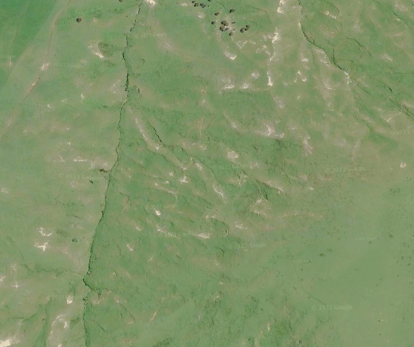
Google Earth
And yet this is repeated across the country.
If nothing else we have shown to be slow learners.
However, I suspect this time around (post Cyclone Gabrielle) the cost to too many will ensure action will occur. Post Bola plantings behind the “Red Line” in Tairawhiti were all done for the right reasons; that is, protect the land for the future and protect those living downstream. However, poor later planning and enforcement has led to the serious predicament the “Coast” and elsewhere has found itself in. This can’t be allowed to be repeated as the fog of time dims the memories.
I think all the “Sustainable Development” definitions I looked at had the common theme that the resources to operate should be left intact so that those following can also operate in the same environment.
27 Comments
I drove from kaukopakopa through to west auckland, down some back roads the other day and there was a massive area of recently harvested pine complete with heaps of remaining slash, not even 50km from Auckland CBD........ My girls took pictures and just could not believe it, was a real mess.
*Kaukapakapa
How long till "Gabrielle amnesia"?
It is not 'repeated across the country'. It depends on slope, soil type, extent of contour disturbance, cover, and management, along with historic rain and hail corridors which relate back to geomorphology. Lazy generalizations lead to the one size fits all prescriptions like....drum roll....pine plantations.
If Northland, BoP, Coromandel, Tairawhiti, Hawkes Bay, Wairapara, Manawatu, East Coast, Wanganui, Rangatikei, Marlborough, Inland CanterburyOtago don't count as "repeated all over the country" then I guess you're correct.
Going back to a pre-European bush landscape has a major flaw. Pre-human bush had multiple species of mid -storey browsers - the moa. If we go back to that with abandon, we'll need to make sure we retain mid-level browsers that have filled that ecological niche - deer. The alternative will be impenetrable bush with low species diversity, and few options besides poison to control the threats to our birdlife.
NZ never learns.
Forests in most cases are the answer - but then not to log them in many places and if risky very carefully. Much of the Bola plantings were done as Protection forests then Governments, of all colours, sold them to Production forests - madness.
In storms debris will come from all forests - I just had a farming friend on the West Coast send me photos of large native trees/logs pouring down on this paddocks and fences etc from the DOC estate yesterday - thats nature Im afraid and our beaches prior to human clearance were all covered in debris, wood in varying amounts depending upon the storm timing and intensity. Nature did not set our beaches up for picnics, walking the dog and surfing - we do those when nature allows or should.
The biggest contribution of soil, silt is farmland that needs to be retried into permanent forest cover or production forest, where suitable. Looking at farmland in many regions the reality is most farmers still hate trees of any type and spray, graze and clear with merry abandon to grow another blade of grass. Just look at Google earth and see large areas of regenerating manuka/kanuka sprayed with Meltsulfuron each year. Gisborne council had a plan years ago that by 2022 large areas of farmland had to be planted in trees - what happened - nothing - so it just quietly was given up on.
Over 1 million, yes 1 million ha, of farmland has been identified by soil science and hydrology that needs to be retired to permanent forest of some type. As usual farmers ignore and carry on and expect the Taxpayer to bail them out to rinse and repeat yet again. What many don't realise is these erosion events happen on smaller scales all the time and we don't blink an eyelid. Plenty of images and evidence of that.
Heres a link you can use to see the river areas around Napier with before and afterwards.
https://www.smartforest.cloud/gabrielle/index.html
Miles of willows and polars in rivers gone. Damage everywhere in pasture and some young pine stands. Houses in obvious flood plains.
What is the definition of insanity again?
Spot on Jack. I'd give your comment 10 upvotes if I could. Much of current farming practice has gone little beyond 'slash and burn' since NZ was settled by Maoris, then Europeans.
100%… what gets me is the diversion tactics of the farming lobby group and dumb journalist looking for the big bad corporate (forest owner) to pin it on!
the layman swallows it hook-line-sinker
Even before the bad weather of the last few years Gisborne and other places had a "wall of wood" problem with many post Bola plantations reaching maturity at the same time.
The trucking of logs was smashing up many of the roads beyond the ability of budgets to cover the costs. And many sections had no feasible access road, so the assets were marooned unless access roads were built. I wonder if these sections will now just be left. Is mature pine forests an option in perpetuity, or will it be a fire risk?
A lot will be left.
We have a high degree of arboreal racism in NZ. We say insects, birds etc won’t live in exotic forests. Last I looked birds and insects don’t read books or have the internet. They don’t care. They will go to cover that produces food, shelter and safety.
I was on Ulva island a while ago. There’s 160 year old pines and macros left from pioneer days. Tut Tut went the guide as they are surrounded by native plants just like the Rimu, Birds in the trees etc. The Kaka there strip the totara bark for insects etc. Alongside that they are stripping the macro bark because the same fauna lives there. The Kaka don’t care what it is they just want food. I pointed this out to silence and confusion of the guide who didn’t know what to do or say. The punters on the trip got it very quickly.
We had a pine stand to harvest that was full of kiwi. At great cost all the kiwi where caught and relocated to a native stand around 5km away. Turn up a week later and the kiwi had said - stuff that and relocated back to the pine stand by themselves - Better food and shelter. Not logged in the end.
Dont these kiwi realise that is not allowed or correct!!
on steep skeletal soils large exotic, and native, trees are not suitable. These slopes will only have smaller shrub forest and will slip. We are going to have to work out how to remove large exotics from these slopes and soils. The rest can be left to transition over 200 years - a blink in ecological time scales.
We need better understanding of the laws and rules of ecology, physics, chemistry etc as no law passed by a politician or article by a writer can change these.
To easy to blame climate change than human stupidity!
Bola didn't learn from the 1938 flood's of Esk valley!!! .. which was ten time worse..
History repeats itself because fools do nothing.
I have no sympathy for people who suffer from the same things 2x... Let alone 3x...
Here on the lower Coromandel , we're( nothing official, just a few mates trading experiences) still trying to figure out why the huge amount of damage, from what for us was a large amount of rain, but not expontenially so , as the damage was. So far we have observed the groundwater level was saturated from previous rain , after 3 years of large rainfall deficit . What this does to the underlying structure is hard to see , but the slipping seemed to occur below tree root level , and all of a sudden . Everyone is describing a pulse like effect , like the ground just got to a point and let go, with the resulting rush of water.
Its quite telling that nearly a month later , these backroad stories are just coming out, and i think they will be a lot learnt for future proofing or adaption.
That's a good point. Hale pre loaded the soils to saturation along with starting and loosening up soils. Gabrielle was the final straw - a garden hose would probably have started a lot.
Many slip-planes are well below tree-root reach. I manage (own, they say) a major one which we've managed the planting of for nearly 30 years. Other local sites have had ' catastrophic failures', but ours has slowed and stayed intact.
You cannot suck the water from the slip-plane, but you can slow it's getting down there. Evapo-transpiration is the key (sucking the moisture and letting it evaporate). For this, tall trees are not the best - and they can lever the soil if they fall. The best, in my experience - is flax. Huge sucker of water, resilient as old boots, splittable, no leverage/weight. Sucks right through winter too. ;
That said, we've not lost tall trees on the site either.... our bonus has been to never expect money from it; we bought it to do good physical things to the land; call it a legacy.
Large clump of flax on riverside near my place, ill check it out tomorrow.
Top rate article thanks Guy. The lack of ground cover on farmland seen in before and after Gabrielle photos in the Hawkes Bay region in national news showed widespread lack of ground cover... not even grass... BEFORE the cyclone..
Careful study of the before/after satellite pics from LINZ quite clearly showed the most unstable land to be farmland, followed by scrub/regenerating bush, and least unstable by a factor of about 20:1 was plantation pine forest.
Even recently harvested forest lands held together well, thanks to the roots that remained deep in the ground.
There was one area where a pine forest had a surrounding skirt of other trees (species/mix/age unknown). The skirt had eroded out. The pines stood firm.
I seriously question how much forest slash gets mobilized only because slips on farmland have created dams, greatly raising river levels and then releasing it all in a tsunami of mud and water which can then race across ground that was formerly well above any predictable flood height.
All those metres of silt came from farms, not from pine plantations.
To be fair some sites, mainly EC steep lands, need serious practice changes and retirement in some. From harvest to around age 6 to 8 there is risk of slips and debris being mobilised in big storms. We need to work out high risk areas and retreat and on others make sure we minimise debris left. You can't remove all risk but we can reduce it by a large margin.
Ultimately if you get a massive event with pre loaded soils via moisture you can't stop everything. That applies to pasture and young forest sites well sited. We just need to be honest about where we do things and understand risk far better to reduce damage. We can't avoid all risk.
Yes, Hemi. My father was 4 years old when he awoke to see the chopping block floating past his window. 1924. Esk valley. The family lost everything and had to walk off their farm.
I did have to laugh a few times when I saw some council 30-something year olds talk indignantly about Bola on TV like they were there. I wonder if they had actually studied it properly or were just working on anecdotes passed down from parents.
Then there is the particular dynamics of rainfall intensity to overlay or include in the consideration.
Hi definition satellite imagery I received yesterday clearly shows that there are relatively confined areas with much higher land slipping incidence, at first glance, irrespective of slope and other geomorphological characteristics. This leads me to ask whether there is considerable, localised variation in actual rainfall pockets within the greater affected area than was officially of farmer recorded for the area.
There is considerable spatial variation in land damage, over quite small distances of 2-5km.
Is this due to meteorological change in the behaviour of storm systems that have hit this year? Perhaps more akin to tropical monsoonal weather systems?
This is exactly what happens. You can get bursts of rain of ultra heavy intensity in small areas that cause massive damage. You can’t map where these might be. I’m many cases the intensity is so great that nothing can with stand them. Slope and soils do play role as the steeper and more susceptible soils will fail more easily. There is always risk even with the best landuse planning but we can reduce, not eliminate, a lot of it.
Agreed. Metservice rain radar showed a confined blue and red patch over Pukeiti Rhododendron gardens just north of Mount Taranaki for 24 hours in the midst of Gabrielle. Looked liked thunder storms but Canterbury is a bit far away to see and I couldn't convince son to go for a drive. The rest of Taranaki did not seem to be getting rain. Presumably the SE airstream was split then air lifted by the smaller mount Patuha to the north. Nothing to the west presumably as no hill to lift it. Just a nice example of the subtleties of rain and topography.
Absolutely. That's what I was getting at in my riposte to the sweeping generalization in the article that everywhere is affected and all landowners are to blame. Bzzt, incorrect. Slash damage is essentially a NI East Coast issue, with very isolated, and thus by definition, minor, issues elsewhere. And we ain't in any position to change geomorphology and it's considerable influence on weather patterns and rain or hail corridors.
I woke up the morning after , and thought we got off lightly. Virtually no surface water outside our house, and the drains contained. Then I got the the phone calls that my workshop had 1/2 a metre of water through it ( 3k.m away ), and there was a metre of water flowing through my lifestyle block lower paddocks (5 k.m away ). As I posted earlier , stories coming out now of huge damage on some farms , others hardly touched . Literally, neighbours not realising how badly affect effected the farm just down the road was hit.
An observation from farmers who have undertaken considerable riparian retirement and protection - watercress has been the single greatest contributor to fence and culvert blow out.
Squash vines have also been a major contributor on lower flats.
In my southern Hawkes Bay area, flood water level was considerably higher than previous events- at least 30cm higher through Porangahau Village than 2004 (purportedly the previous record) and that draws on old oral histories from our Maori community.
We welcome your comments below. If you are not already registered, please register to comment
Remember we welcome robust, respectful and insightful debate. We don't welcome abusive or defamatory comments and will de-register those repeatedly making such comments. Our current comment policy is here.